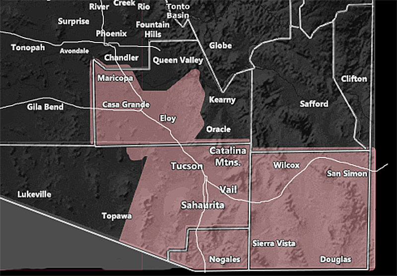
Issued Zones: Cochise and Santa Cruz County … Eastern half of Pima County … Western, Southern, and Central Pinal County along the I-10 corridor …
Site: Arizona Weather Force has issued a Thunderstorm Watch effective through today …
Date: 8/11/23 at 8:55am PT
Forecast: A vort max is moving north-northeast out of Eastern Arizona into New Mexico this morning, as noted from the rain in Cochise, Graham, and Greenlee County this morning. As this moves out, instability will develop behind it and storms will once again form across the watch area through this evening.
Storms today will have a northwest moving outflow and attending convergence boundary stretching from Tucson through Casa Grande and into Maricopa as well. This means that storms forming along the I-10 corridor will be in the cards once again today.
Gusty winds, some hail, dust storms, and areas of flooding are all possible today …
Get these alerts over the new Android and Iphone app and/or e-mail service by becoming a full member subscriber today and never miss an update from this office. Remember, you cannot just make an account on the app and get notifications. You must select your zones and then go through the payment process.
Click here to learn more.
Join the Facebook Page for Further Updates If You Have Not Yet!
ARIZONA WEATHER FORCE MAIN:
Join The Main Arizona Weather Force Facebook Group (50 percent delivery time) – You can join the main AZWF page as well through that group.
Click Here To Join The Page Today
10 mile rule: These alerts issued on this site
means that within your zone and 10 miles from you will see the event
forecast for. You may or may not see the event but it means you are in
the zone or 10 miles from where someone will.
Master Meteorologist: Raiden Storm