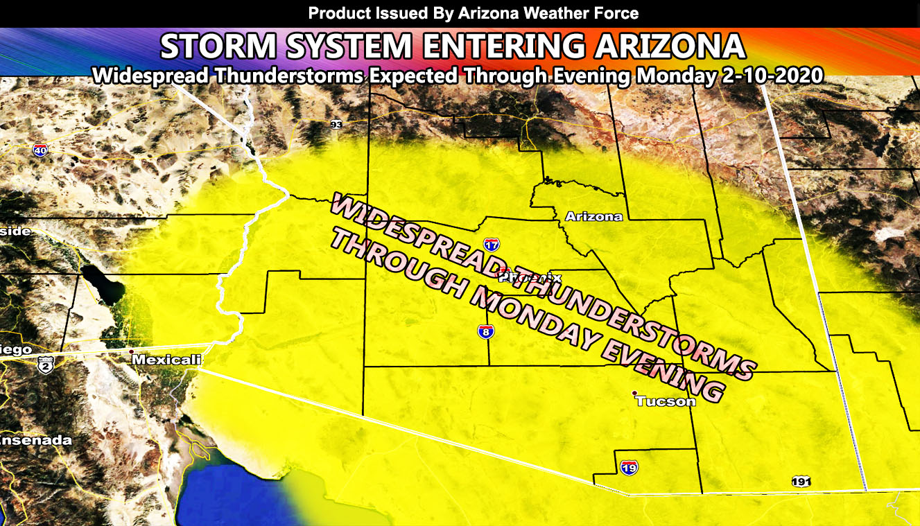
Title usually says it all for you as numerous thunderstorms are set to erupt across the state of Arizona today and a full Arizona Weather Force Thunderstorm Watch issued yesterday remains in effect for today, which will surprise many because outlets have ‘isolated’ only in the forecast. The 200+ mph wind reading in Northern California was an error so read on for details.
As of 8am, lightning has been detected in Mexico, southwest of the state north of the Gulf of California. This is in response to the upper level low moving through Northern Baja, Mexico as we speak and the east end of it is having the upper level divegernce (lifting zone). As the morning moves along, thunderstorms will form and enter Southwest Arizona with the low closing in. This area of upper lift will move north and east through the state for an evening hit for the Phoenix and Tucson metro zones.
These storms will be capable of hail and funnel clouds. There is a dusting on my models for the Payson/Prescott areas overnight tonight with a northern slider on the backside of the upper level low that will cause the thunderstorms today.
The forecast is pretty straightforward.
As for the 200+ mph wind gust reading in Northern California that is going viral. NOAA pulled the trigger too soon. When looking over the data I noticed the mid/upper jet stream could not handle that. In addition to that, the sinking air for a strong gust would need dry air and the station had over 90% humidity at the time. So I’m sure they’ll figure it out soon, but it was not possible given the atmospheric dynamics vs the reading.
From previous forecast
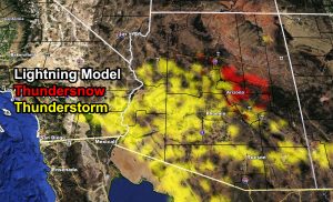
The new lightning strike forecast model has red-shades in it and this is for thundersnow. Being this system will bring snow with it to the White Mountains to Rim areas near Flagstaff, it is very likely you will see snow+lightning and thus thundersnow is born and it has been detected and publicly available to you in this article. There is some risk of severe storms activity in the Tucson forecast area and that will further be monitored for any upgrade.
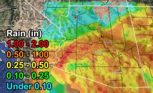
The rain model is showing that Western AZ will see 1-2″ of rain under the strongest cells and even some Northern Phoenix Valley areas. The metros however of Phoenix and Tucson fall within the 0.50-1.00″ category. I am looking in addition to you being in the Arizona Weather Force Thunderstorm Watch that Flood Advisory criteria will be met in both metro zones so I would expect some urban street flooding at times.
Snowfall will be rather light in the Flagstaff forecast areas with a slight nudge in storm trajectory over the last 24 hours. The heaviest snow will remain in the White Mountain areas. Use the snow model below for this.
The system backs out on Tuesday with the risk of left over thunderstorms in Southeastern Arizona. We are losing the next weekend system fast in long range numbers so at this time I will be removing this system to all but Northern Arizona for after the 14th and will work on the micro-climate e-mail alert system members only as the main Facebook Page is if the entire state, or most metros, will be affected. If you haven’t signed up for that service which keeps this info flowing then the link is below –
As you know, just as Southern California Weather Force has a service for members with micro-climate alerts, Arizona Weather Force does as well and we do have some people already signed up getting those so it is seeming like it is helping. The service helps businesses and persons, especially with ranches. Click Here to read about it and even join.
NOTE: This is the SCWF Website but it is being used for national updates until ad placement is ready on the AZWF site.
Your Facebook Page to join for this update is linked here – https://www.facebook.com/ArizonaWeatherForce