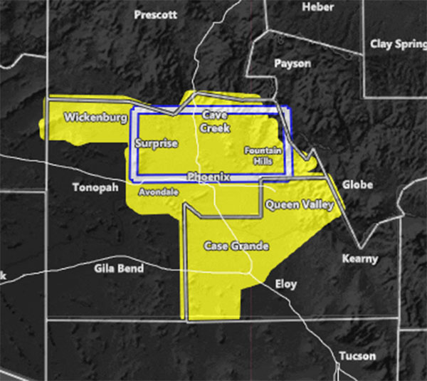
Issued Zones: Northern half of Maricopa County … Northwest half of Pinal County …
Site: Arizona Weather Force has issued a Severe Thunderstorm Watch from 7pm till 11pm tonight …
Date: 7/12/21 at 3:00pm PT
Forecast: A disturbance form storms east of the two counties will move due west tonight around 8pm or so, with a window of 7pm to 11pm. This disturbance is already going to be in the regular thunderstorm watch box issued earlier in the morning for these areas, however recent data suggests strong downward instability for the damaging wind factor to take hold. On top of that, short-range models are all over the place with this activity, but by looking at the upper-level divergence, we have that and convergence at 10,000 FT. This all points to storms cross this region tonight.
It is important to note that not everyone would see it, as is with all storms. EVERYONE will see Tuesday night’s activity though, and it should make tonight and the previous days look like a cakewalk.
Regardless, the focus spot for tonight’s activity would be off Gila County within the boxed area on the map for this alert. The boxed area is along Northern Maricopa County. The city that I pick to be closer to the center of the dynamics is Rio Verde and spreading west from there.
Those of you down in Pinal County have been included in this watch just in case the calculation was off and storms extend further south, but you are not in a focus spot like Rio Verde is. You can see the shape of the watch is like a fan coming from Gila County. That is where all the storm outflow is coming from, fanning out from there across the two zones.
Still, you can keep an eye on trends, but remember Tuesday night is when the worst of the entire event hits these parts… and everyone in this watch will see it.
SEVERE STORM STRENGTH …
Damaging Winds – 60% – Moderate
Large Hail – 40% – Low to Moderate
Tornado – 10% – Low
10 mile rule: These alerts issued on this site
means that within your zone and 10 miles from you will see the event
forecast for. You may or may not see the event but it means you are in
the zone or 10 miles from where someone will.
– is a consulting meteorologist for over 50 different companies,
including large oil companies like BP. He has certs from MSU and PSU as a
meteorologist. Both short and long-range is very important to know in
those jobs so you can bet on accuracy here. He is versed in fields like
Western USA, Tornadoes, Floods, Hurricanes, High Winds, Fire Behavior,
Snow and Blizzards, Short Range, Long Range, Seasonal, and
Life-Threatening decisions with over 20 years experience,
out-forecasting even the National Weather Service with lead-time and
precision, which makes him a focus of ridicule and envy in the weather
community due to having such accuracy.
Forecaster: KM