First of all, Facebook looks to be throttling the Arizona Weather Force page if I post article links so that is why it is an image with a link embedded. They seem to show it to more newsfeeds. Again, another reason I stated one must be on the premium member e-mail alert system to receive this 100% There is no other way around it. Now for the forecast…
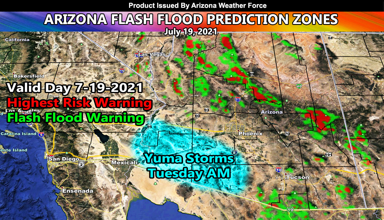
This is the experimental Flash Flood prediction model here at Arizona Weather Force. It only has two color values, Flash Flood Warning criteria, and High-Risk Flash Flood Warning. Consider it a prediction of where future issued flash flood warnings will be issued. It takes the amount of moisture vs strength of the storm and gives a flood threshold algorithm to give an idea of who will see what or what roads to avoid.
Today, it is clearly obvious that Phoenix will not see anything. Flagstaff’s forecast area will get nailed, Prescott being surrounded, and there will be storms coming from the east through Tucson.
NOTE: This is for the peak daytime heating and not overnight. Also note that there is an area of disturbance that will cross Southern Arizona overnight tonight, hitting Yuma and the Central CO River Valley areas early Tuesday morning before or around sunrise. This will be monitored further and a thunderstorm watch will go out over the e-mail alert system if needed for those areas. So yes Yuma, you finally get some rainfall early Tuesday morning so enjoy that. All alerts also go on the AZWF Facebook Group located in the links below in the article and the comment section of the Arizona Weather Force page.
Arizona Weather Force still has a Flood Watch in effect for the metros starting middle this week and going from there several days – If you missed that, Click Here.
To better view, these maps are the zoom-in maps of the map in this article, and they are clickable – Zone 1 is NW AZ, 2 is NE AZ, 3 is SW AZ including Phoenix, and 4 is SE AZ including Tucson.


Get these alerts via your own e-mail control panel for your zone at 100% where social media IS NOT, or the closest to you as a full supporting member of this service that saves lives and property – here – http://arizonaweatherforce.com/azwf-discount-member-sign-up-page/
Join the Arizona Weather Force group for photos and pictures, and sometimes updates not posted on the main FB Page – here – https://www.facebook.com/groups/arizonaweatherforecasts
See ALL Active articles and alerts for Arizona here – http://arizonaweatherforce.com/
Arizona Weather Force is a custom weather alert service that began in September 2019 off of Southern California Weather Force and is regarded as the most accurate weather service in the state, offering custom alerts, maps, and models to help save life and property. The work done here is never 100% accurate, but it comes pretty close. Arizona Weather Force runs on zones, so if an event happens in a zone that is 10 miles from the border of your zone, the forecast is still valid to activate your zone’s alert system. A company quote to the public is that of “The Joker” and tells other agencies in weather this all the time… “This world deserves a better class of meteorologist… and I’m gonna give it to them”… out-forecasting even the National Weather Service with lead-time and precision, which makes this service a focus of ridicule and envy in the weather community due to having such accuracy. Alerts issued here are issued custom from this office and this office alone. You may not even hear it elsewhere, but if one is issued near or in your area, listen up because “if you do not wish to die in weather, follow, it’ll save your life one day.”