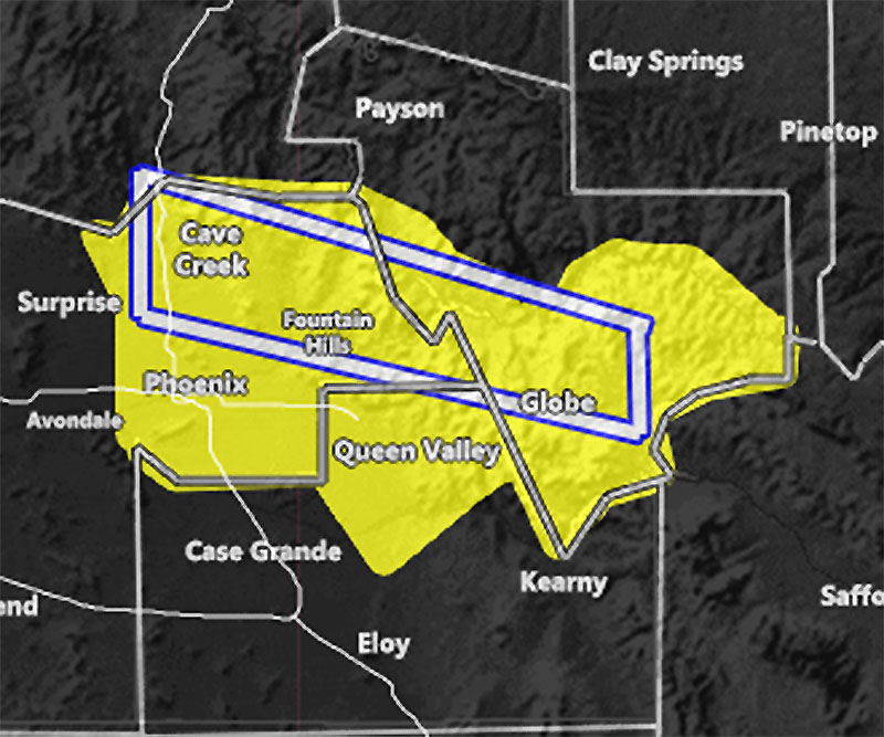
Issued Zones: Eastern half of Maricopa County … Northern Pinal County … South/West Gila County including Globe …
Site: Arizona Weather Force has issued a Severe Thunderstorm Watch effective midnight tonight through 12pm Wednesday, concerning marginally severe hail and weak tornado …
Date: 8/17/21 at 7:35 pm PT
Edited Watch Extension Time was at 2:45a – 8-18-2021
Forecast: A Mesoscale Convective Vortex left behind from last night’s system will move northward toward the PHX valley areas, mainly along and east of I-17 and along I-10 to US 60 east. The PVA (Positive Vorticity Advection) moves in after midnight tonight, and increases as the early morning (before and at sunrise) moves along.
This Severe Thunderstorm Watch has a box. In this service, the box is generally used to highlight the best area within the zone areas shaded. If the box crosses a zone, it is highlighted, so you may not be getting this event, but it is close enough that your zone has been highlighted. So understanding that will understand how these work.
The reason the box is mainly affecting areas north of US60 and east of I-17, within that area of Northeast Maricopa County is that this event has southerly flow. That means that the closer you are to the foothills the better chances of orographic lifting caused by them for these to form.
Storms will form quickly and out of nowhere. These storms will be capable of mainly marginally severe hail. Downdraft instability values are not too high, so damaging winds are not the main cause for this watch, but some cells will have gusty winds near and under them.
WEAK TORNADO – This is a synoptic system. Due to the trough of low pressure entering the Great Basin, the southerly flow will generate a southeast backing flow into the cells. This, with instability present and no surface capping, with marginal shear, may just make it possible that some of these stronger cells will produce a weak tornado. However, because the area is small, it would preclude the need for a tornado watch, BUT, as I stated, this is a synoptic pattern, not just a monsoonal flow.
Airmasses are colliding in this area during the watch period.
Off and on storm activity in this area is expected through at least 9 pm on Wednesday. If you are a weather spotter and you are near anywhere along I-17 east and US 60 north… near Fountain Hills or Cave Creek’s forecast zone, you have your window to see if you can get a weak tornado out of one of these cells.
As stated, there is a chance most of these cells will be north of the populated areas like Gilbert/Mesa and so on, but your zone is still highlighted in case of error so don’t get mad at me if I am right and they are along I-17 and east.. and north of US60 with the strongest cells …