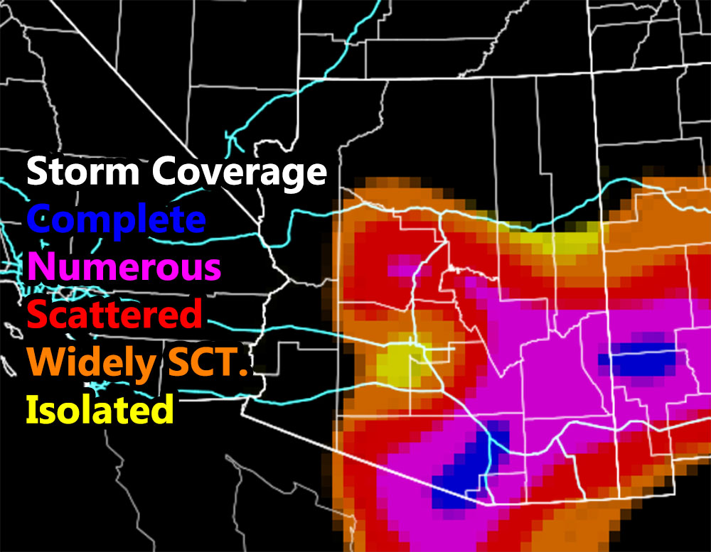
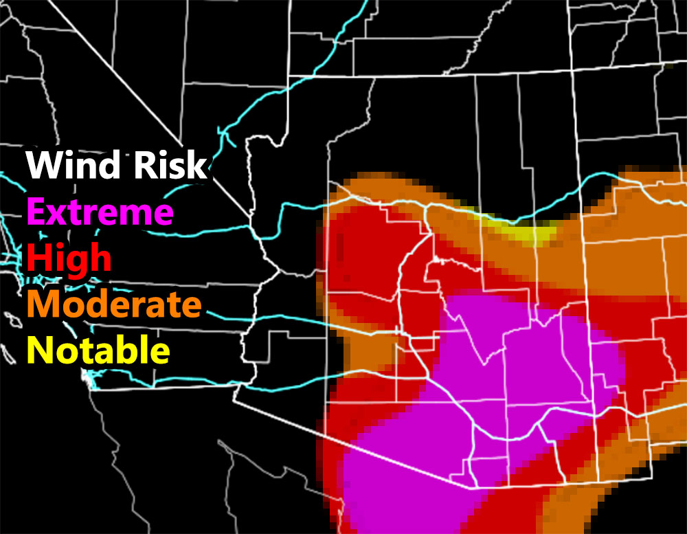
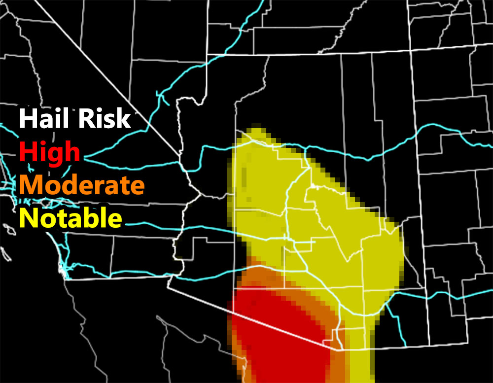
Boy oh boy where do I begin with this. New CPU power has allowed me to finish the storm coverage model. You can be shaded in a severe thunderstorm watch, yet it would be nice to know the storm coverage expected. Whether you are hit and miss, scattered, or even complete coverage, the new Arizona Weather Force model will attempt to squash those questions down, further bringing accuracy to this weather service. For the hail, wind, and new storm coverage models, those images are below if reading from the alert system main site link, if reading from the Facebook Page, the link is in the comments below, titled “Severe Weather Issued For Arizona for August 28, 2021; New Storm Coverage Model Introduced; Southern Half of Pinal County to All of Pima Expect Damage” – Go there …
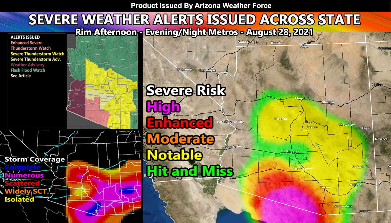
Now onto today. Arizona Weather Force has issued several alert over the alert system. So let’s start with the strongest and move to the weakest. ALL alerts go from now through tonight …
Enhanced Severe Thunderstorm Watch – Issued for Central to Western Pima County, including Topawa and Ajo, north to near Gila Bend. Storms developing today AND coming through the area tonight will be capable of damaging winds and hail. This is the area where both the combination of severe hail and damaging winds comes together the most. It’s rather rural, but I know people reading this live in those areas. Now you know.
Severe Thunderstorm Watch – Storms are expected to form along the entire Mogollon Rim today, and mountains east of Tucson and Eloy/Kearny. This storms will shift south and west through the later afternoon/evening hours and move into the lower terrain. Stronger instability existing will bring mostly a damaging wind event to the areas within the watch zone. Again, check the models I provide below or in the link in the FB comment section to see your overall coverage within that zone. Storms are expected to be damaging for the south/east half of Pinal County to the Tucson area, where Tucson you will take a direct hit. So the forecast in other areas for 20% chance of storms, is 200% chance of damaging storms on my grids. Tucson, not only are you in a higher risk damaging wind event, you are also in the ‘complete’ category for the new storm coverage model, which means you are going to get hit. Leakage of severe storms may hit the Wickenburg areas, east along the border of Maricopa/Yavapai County, as further noted in the storm coverage model as well.
Severe Thunderstorm Advisory – This advisory is lower than the watch, but does indicated that hit and miss storms capable of severe hail and/or winds will be likely. In this zone, mostly the populated areas of the Phoenix Valley, including Queen Valley to Casa Grande and San Tan, the hail risk model is ‘notable’ or a lower risk so UP to 1 inch of hail is possible in the strongest cells in these zones, but the wind damage model shows a higher risk… so in essence the forecast for the PHX Valley areas would be, “hit and miss storms, some severe, capable of semi-large hail, and damaging winds in the strongest cells” this evening/night.
Weather Advisory – Near Quartzsite today, probably closer to the city of Brenda, storms will form along I-10 in La Paz County. This should be an isolated kind of event and the models do not show it, but it is possible. Your weather advisory if of along the southern half of the CO River Valley for the way overnight, into Sunday morning mainly with ANY outflow that may arise from storms to your east. It is not a full thunderstorm watch, but the outflow could easily pop storms in that area, especially with the easterly wave crossing into Southern California from Arizona on Sunday morning.
The following models are clickable and go from now until 4am Sunday morning –
BONUS: For a bit of time I will allow non-members to see the member section of AZWF. During Fall, Winter, and Spring, the member section has zoom in models during events predicted. They are placed there in the tabs, this one is the heat model. It contains a zoom-able model so you know where you are on the map. Better yet, members can enter a city and address in the search bar and it zooms right down into that level. This is a medium resolution map, the other ones AZWF has at disposal have higher resolutions available during storm events from rain, wind, snow, and flood.
CLICK HERE TO ENTER THE MEMBER SECTION TO TRY IT OUT. Note, this does not include the e-mail alert system, just the visuals of the models provided.
If you like it… Click Here to become a full member and get those zoom in models + the e-mail alert system where you choose zones to receive custom alerts.
Get these alerts via your own e-mail control panel for your zone at 100% where social media IS NOT, or the closest to you as a full supporting member of this service that saves lives and property – here – https://arizonaweatherforce.com/azwf-discount-member-sign-up-page/
Join the Arizona Weather Force group for photos and pictures, and sometimes updates not posted on the main FB Page – here – https://www.facebook.com/groups/arizonaweatherforecasts
See ALL Active articles and alerts for Arizona here – https://arizonaweatherforce.com/
Arizona Weather Force is a custom weather alert service that began in September 2019 off of Southern California Weather Force and is regarded as the most accurate weather service in the state, offering custom alerts, maps, and models to help save life and property. The work done here is never 100% accurate, but it comes pretty close. Arizona Weather Force runs on zones, so if an event happens in a zone that is 10 miles from the border of your zone, the forecast is still valid to activate your zone’s alert system. A company quote to the public is that of “The Joker” and tells other agencies in weather this all the time… “This world deserves a better class of meteorologist… and I’m gonna give it to them”… out-forecasting even the National Weather Service with lead-time and precision, which makes this service a focus of ridicule and envy in the weather community due to having such accuracy. Alerts issued here are issued custom from this office and this office alone. You may not even hear it elsewhere, but if one is issued near or in your area, listen up because “if you do not wish to die in weather, follow, it’ll save your life one day.”
Meteorologist In Charge – ![]()
![]() – is a consulting meteorologist for over 50 different companies, including large oil companies like BP. He has certs from MSU and PSU as a meteorologist. Both short and long-range is very important to know in those jobs so you can bet on accuracy here. He is versed in fields like Western USA, Tornadoes, Floods, Hurricanes, High Winds, Fire Behavior, Snow and Blizzards, Short Range, Long Range, Seasonal, and Life-Threatening decisions with over 20 years experience, out-forecasting even the National Weather Service with lead-time and precision, which makes him a focus of ridicule and envy in the weather community due to having such accuracy.
– is a consulting meteorologist for over 50 different companies, including large oil companies like BP. He has certs from MSU and PSU as a meteorologist. Both short and long-range is very important to know in those jobs so you can bet on accuracy here. He is versed in fields like Western USA, Tornadoes, Floods, Hurricanes, High Winds, Fire Behavior, Snow and Blizzards, Short Range, Long Range, Seasonal, and Life-Threatening decisions with over 20 years experience, out-forecasting even the National Weather Service with lead-time and precision, which makes him a focus of ridicule and envy in the weather community due to having such accuracy.