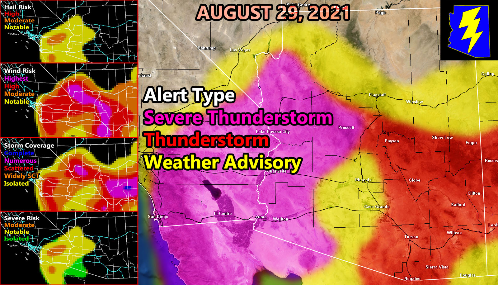
Arizona Weather Force has issued several alerts over the alert system. So let’s start with the strongest and move to the weakest. ALL alerts go from now through tonight and yes this is, as always, a very detailed forecast outline to read. I introduced the storm coverage model yesterday, and with the new CPU power I got with YOUR HELP to expand, I also have my alert system algorithm as it takes all four models I have now and gives an idea what type of alert to place you in.
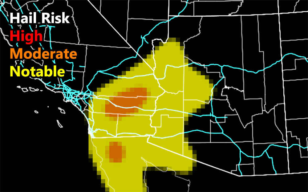
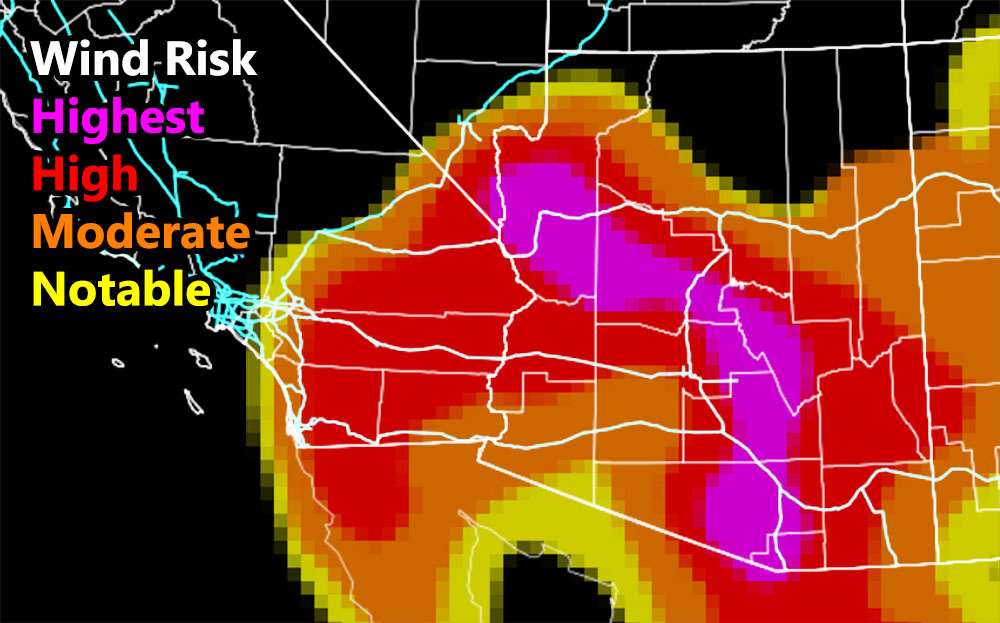
Severe Thunderstorm Watch – Zones affected – Western half of Arizona, including Kingman, Yavapai County, Yuma County … The entire Colorado River Valley areas around Havasu – Storms are expected to be the most severe out of the state here, whereas yesterday it was the southern part of Arizona. The same impulse that give Tucson the severe storms yesterday has moved west through the CO River Valley and the residual effects of it will pop off Scattered to Numerous Thunderstorms for Yavapai, Kingman, and the Havasu area through the watch period. Severe hail is possible, up to 1″ in diameter, but the main concern is the damaging winds where an enhanced to high risk is being noted. Dynamics are still for severe as these moves southward later in the period toward Yuma County, but you’re in a ‘moderate’ wind risk and and a marginal severe hail risk so you’re on the weaker end of the watch area.
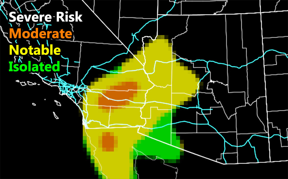
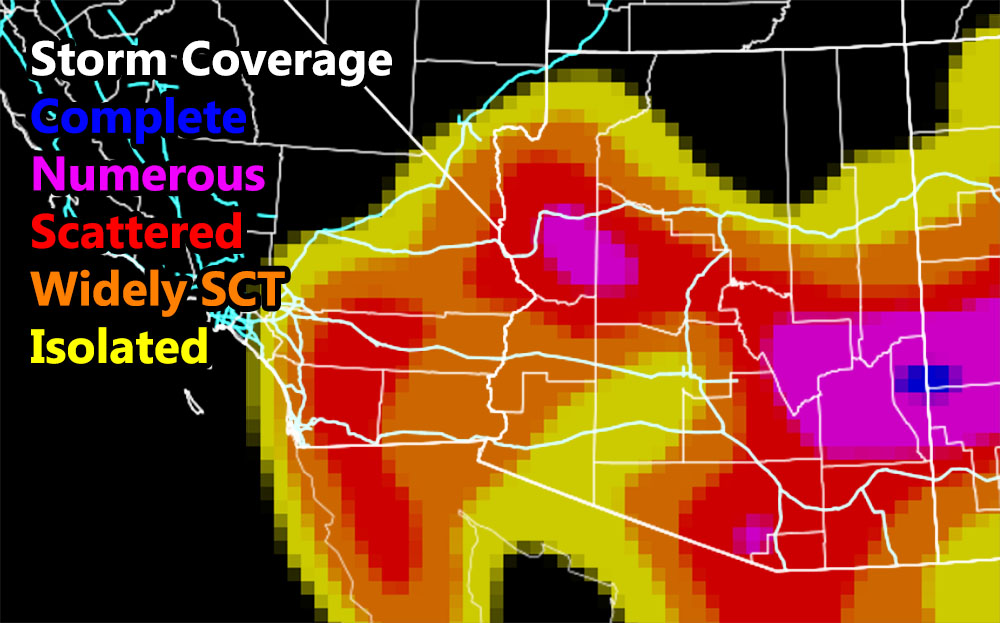
Thunderstorm Watch – The Severe Risk model shows most of the combination of wind and hail is in the Western half of Arizona. In order to gain a severe risk value on my model, it combines the need to have BOTH wind and hail damage, upping the risk. All storms outside of it in the thunderstorm watch area do have the potential for strong winds, but not for larger hail. The thunderstorm watch expands the entire Mogollon Rim again, the Prescott in severe, and the regular thunderstorm watch starting at Camp Verde and going east through the entire rim, south through Clifton/Safford, into Cochise County, west through Tucson, and north through the eastern half of Pinal County, and extreme Eastern Maricopa County. Leakage from thunderstorms and outflow may very well bring storms to Queen Valley, Tortilla Flat to Sunflower.
Weather Advisory – The weather advisory is mainly for Flagstaff and Phoenix’s forecast area. Although no severe risk for hail, strong winds with any developing storms in the valley will be possible in this period. The storm coverage model shows isolated for Phoenix and north and east of there the widely scattered category. So I decided a weather advisory, weaker than a full thunderstorm watch, would be the best thing to add today.
Those focus areas surround Bagdad and Kingman, Arizona for both the severe risk, severe hail, damaging wind potential, and numerous storm coverage. These are my picks for the worst out of the region today.
NORA: Many are asking if Nora will move east of Arizona. No, she will be south of Arizona and what many are missing is the upper-level easterly wave (low) that is moving across Baja today. This will exit into the Pacific Ocean west-southwest of San Diego, CA and this will draw the deep-layer moisture from Mexico, north-northwestward into Arizona. That is why in my previous and only forecast video I stated it doesn’t matter where it hits, this flood event is solidified into history already.
HERE ARE THE FOUR ARIZONA WEATHER FORCE MODEL IMAGES FOR TODAY/NIGHT – THEY ARE CLICKABLE. THEY ARE THE IMAGES ON THE LEFT OF THE MAIN IMAGE ABOVE –
As always, Stay tuned to Arizona Weather Force for future updates –
BONUS: For a bit of time I will allow non-members to see the member section of AZWF. During Fall, Winter, and Spring, the member section has zoom in models during events predicted. They are placed there in the tabs, this one is the heat model. It contains a zoom-able model so you know where you are on the map. Better yet, members can enter a city and address in the search bar and it zooms right down into that level. This is a medium resolution map, the other ones AZWF has at disposal have higher resolutions available during storm events from rain, wind, snow, and flood.
CLICK HERE TO ENTER THE MEMBER SECTION TO TRY IT OUT. Note, this does not include the e-mail alert system, just the visuals of the models provided.
If you like it… Click Here to become a full member and get those zoom in models + the e-mail alert system where you choose zones to receive custom alerts.
Get these alerts via your own e-mail control panel for your zone at 100% where social media IS NOT, or the closest to you as a full supporting member of this service that saves lives and property – here – https://arizonaweatherforce.com/azwf-discount-member-sign-up-page/
Join the Arizona Weather Force group for photos and pictures, and sometimes updates not posted on the main FB Page – here – https://www.facebook.com/groups/arizonaweatherforecasts
See ALL Active articles and alerts for Arizona here – https://arizonaweatherforce.com/
Arizona Weather Force is a custom weather alert service that began in September 2019 off of Southern California Weather Force and is regarded as the most accurate weather service in the state, offering custom alerts, maps, and models to help save life and property. The work done here is never 100% accurate, but it comes pretty close. Arizona Weather Force runs on zones, so if an event happens in a zone that is 10 miles from the border of your zone, the forecast is still valid to activate your zone’s alert system. A company quote to the public is that of “The Joker” and tells other agencies in weather this all the time… “This world deserves a better class of meteorologist… and I’m gonna give it to them”… out-forecasting even the National Weather Service with lead-time and precision, which makes this service a focus of ridicule and envy in the weather community due to having such accuracy. Alerts issued here are issued custom from this office and this office alone. You may not even hear it elsewhere, but if one is issued near or in your area, listen up because “if you do not wish to die in weather, follow, it’ll save your life one day.”
Meteorologist In Charge – ![]()
![]() – is a consulting meteorologist for over 50 different companies, including large oil companies like BP. He has certs from MSU and PSU as a meteorologist. Both short and long-range is very important to know in those jobs so you can bet on accuracy here. He is versed in fields like Western USA, Tornadoes, Floods, Hurricanes, High Winds, Fire Behavior, Snow and Blizzards, Short Range, Long Range, Seasonal, and Life-Threatening decisions with over 20 years experience, out-forecasting even the National Weather Service with lead-time and precision, which makes him a focus of ridicule and envy in the weather community due to having such accuracy.
– is a consulting meteorologist for over 50 different companies, including large oil companies like BP. He has certs from MSU and PSU as a meteorologist. Both short and long-range is very important to know in those jobs so you can bet on accuracy here. He is versed in fields like Western USA, Tornadoes, Floods, Hurricanes, High Winds, Fire Behavior, Snow and Blizzards, Short Range, Long Range, Seasonal, and Life-Threatening decisions with over 20 years experience, out-forecasting even the National Weather Service with lead-time and precision, which makes him a focus of ridicule and envy in the weather community due to having such accuracy.