No way to put it, Tucson was hammered today without a warning from other weather services. It just boggles the mind how they can miss these things. I will tell you exactly why they do. They are not trained in severe thunderstorm or tornado forecasting. The severe storm forecasts are actually made from a centralized office in Oklahoma. That office issues severe thunderstorm and tornado watches for the entire United States. This is where the error lies and something needs to be fixed or this will continue to happen. Local offices do not have the power to issue those types of watches, and the Oklahoma office that is responsible does not understand Western United States forecasting. I have been sick and tired of it all summer and frankly my entire life. That is why Arizona Weather Force must continue to grow and take over local offices in that sense and I will do that with word of mouth and with your help.
SEPTEMBER 5, 2021 EVENT: Arizona Weather Force’s severe risk models indicated that an Enhanced Severe Thunderstorm Watch needed to be issued for the Southeast half of Arizona, including Safford and Tucson. These areas were hit hard, right in the center of the watch area. There was absolutely zero forecast given for this from local offices. Again, like always, many challenged the AZWF forecast saying ‘their apps or TV says nothing about it’… How about NOW?!? This forecast was made two days ago. I even did a video forecast on it yesterday. The links are below this write-up for those that are interested in proof, because I can always back up my forecasts showing it was predicted and not a ‘surprise’. Those that follow Arizona Weather Force have a better chance at survival than those that do not. Even when warning about property damage, AZWF is fully equipped and capable of providing such.
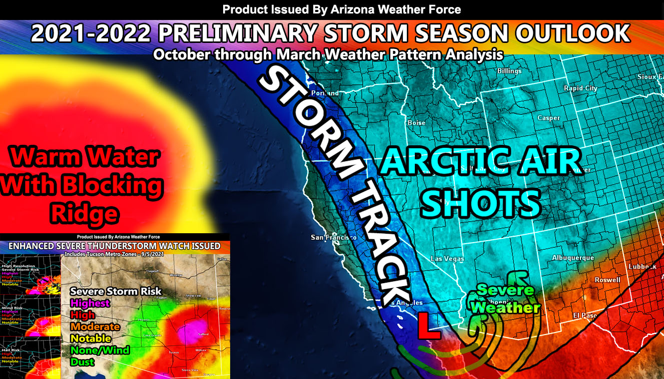
2021-2022 Pattern: This is going to be a very interesting seven months ahead. Key components are developing right now. Water temperature are up about 1000 miles west of Oregon. This warm water creates a strong surface ridge in the area, and it often does make storms go up and over an upper ridge and then down across California and then out to the rest of the United States. When this happens, California goes into a major drought. However, the storm track being over California means that upper-level low pressure centers would be west of Arizona, putting the state in the upper lift section of the storm pattern. These are the types of patterns that bring severe weather from severe storms to tornadoes across the state. It also brings colder than normal conditions for most of the state. The exception is the southern half due to southerly flow.
This warm spot has been growing for quite some time now. My studies indicate, with my own hypothesis, that this might be due to the garbage thrown out there. We have garbage islands out there and the plastic may just be enough to use the Sun and heat up the water (like a magnifying glass) and bring about that warm area 1000 miles west of Oregon. I have no proof, but if that is where the garbage is released within those ocean currents, then that would make some bit of sense because looking back 30 years ago we did not have such a warm spot in that area.
OVERALL: This is preliminary, but as you have seen, a lot of my preliminary forecasts like my summer forecasts have been the same upon the final release. I do not expect this to change much. We will have an average winter both temperatures and precipitation if the shadows of the future remain on their course.
COMMANDING INFORMATION BELOW ON SEVERE THUNDERSTORM EVENT FOR THE SOUTHEAST HALF OF ARIZONA ON SEPTEMBER 5, 2021
INITIAL SEVERE WEATHER STATEMENT LINK (TWO DAYS AGO) – https://www.facebook.com/groups/arizonaweatherforecasts/posts/3136935439963752
FORECAST VIDEO OF EVENT – https://www.facebook.com/ArizonaWeatherForce/posts/662146945178085
ENHANCED SEVERE THUNDERSTORM WATCH ISSUED FOR THE EVENT – https://www.facebook.com/ArizonaWeatherForce/photos/a.119632656096186/662698891789557