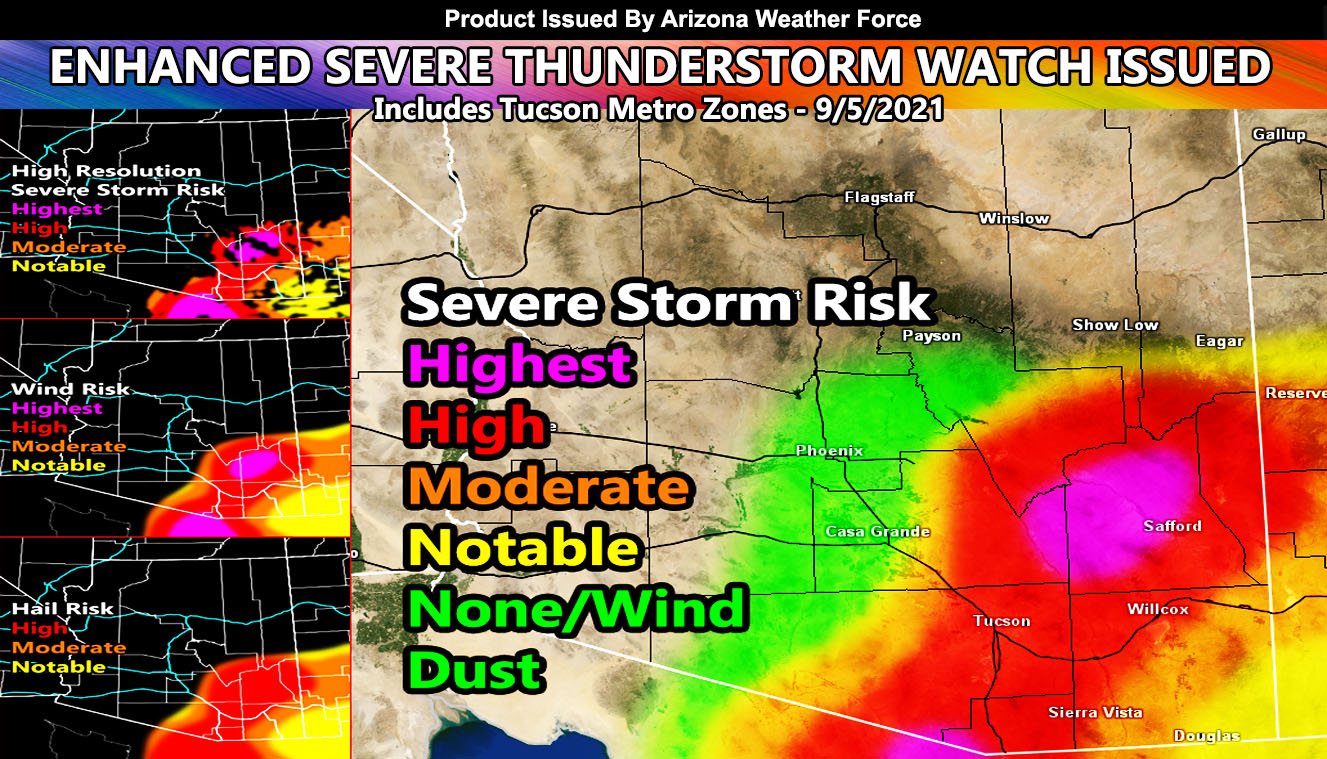
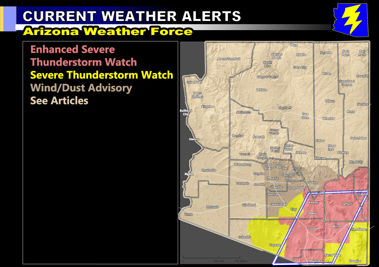
Arizona Weather Force has issued an Enhanced Severe Thunderstorm Watch effective this afternoon through the evening for the following areas; Eastern Pinal and Pima County, includes the Tucson Metro Zones – Santa Cruz, Graham, and Greenlee Counties. Northwest Cochise County. As per the commanding Severe Weather Statement issued two days ago and the video placed yesterday, the ridge of high pressure is positioning itself in Central Nevada. This will bring in northeast flow around it. Upstream moisture is available in New Mexico along with an upper disturbance, which will drive through the Enhanced Severe Thunderstorm Watch zone, first starting over the high terrain this afternoon and spreading into the more populated zones along I-10 through the later afternoon and evening hours. The northern extent of this is around the Kearny areas.
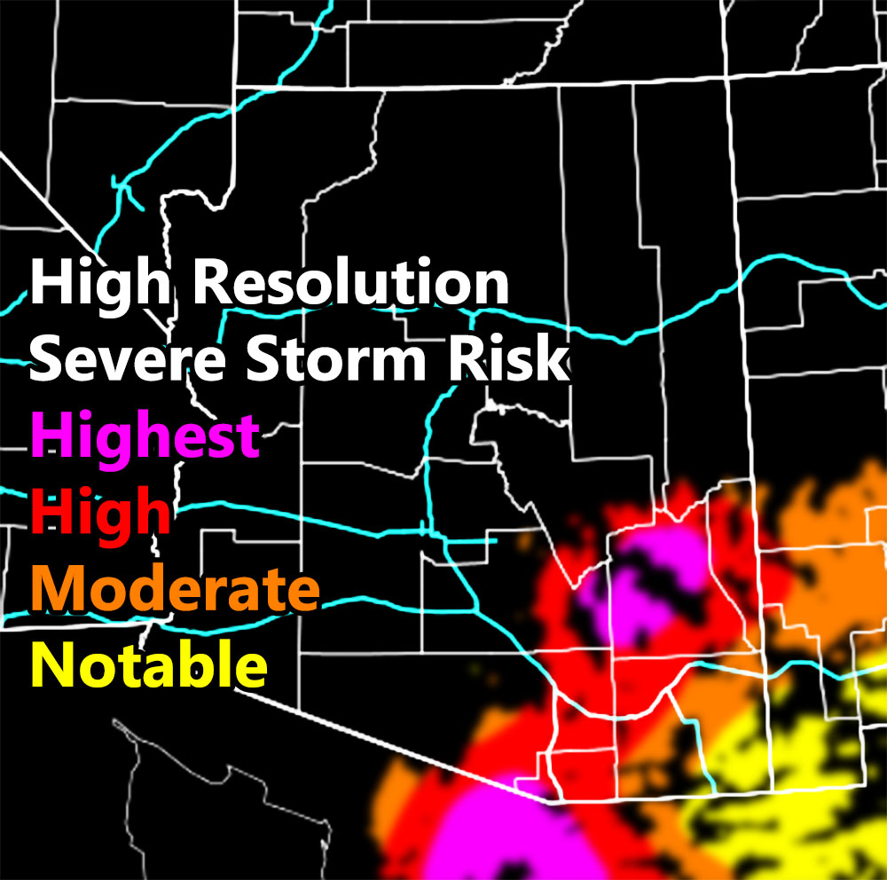
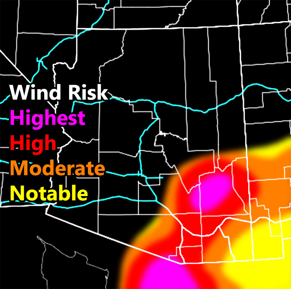
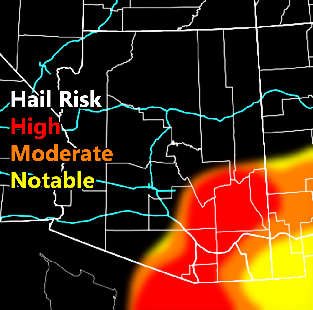
The new high resolution Arizona Weather Force model is attempting at picking areas where the most concentrated areas will be, breaking down the severe thunderstorm risk zone into pockets of concentrated or isolated activity. You can see that model in the image on this post or in the article below for the zoom-in maps of this forecast.
Storms today will be capable of large hail and damaging winds. The Tucson Metro area is pegged as having wind gusts that will bring trees or power-lines down so be mindful of the generators should you have them.
As the storm outflow moves along I-10 northwest toward the Phoenix areas wind gusts of 30+ mph will be possible this evening for the western half of Pinal and eastern half of Maricopa County, thus a wind advisory with dust wording has been issued for you.
Here is the warning map for today – Clickable –
Here are the high resolution models for this event – Clickable –
BONUS: For a bit of time I will allow non-members to see the member section of AZWF. During Fall, Winter, and Spring, the member section has zoom in models during events predicted. They are placed there in the tabs, this one is the heat model. It contains a zoom-able model so you know where you are on the map. Better yet, members can enter a city and address in the search bar and it zooms right down into that level. This is a medium resolution map, the other ones AZWF has at disposal have higher resolutions available during storm events from rain, wind, snow, and flood.
CLICK HERE TO ENTER THE MEMBER SECTION TO TRY IT OUT. Note, this does not include the e-mail alert system, just the visuals of the models provided.
If you like it… Click Here to become a full member and get those zoom in models + the e-mail alert system where you choose zones to receive custom alerts.
Get these alerts via your own e-mail control panel for your zone at 100% where social media IS NOT, or the closest to you as a full supporting member of this service that saves lives and property – here – https://arizonaweatherforce.com/azwf-discount-member-sign-up-page/
Join the Arizona Weather Force group for photos and pictures, and sometimes updates not posted on the main FB Page – here – https://www.facebook.com/groups/arizonaweatherforecasts
See ALL Active articles and alerts for Arizona here – https://arizonaweatherforce.com/
Arizona Weather Force is a custom weather alert service that began in September 2019 off of Southern California Weather Force and is regarded as the most accurate weather service in the state, offering custom alerts, maps, and models to help save life and property. The work done here is never 100% accurate, but it comes pretty close. Arizona Weather Force runs on zones, so if an event happens in a zone that is 10 miles from the border of your zone, the forecast is still valid to activate your zone’s alert system. A company quote to the public is that of “The Joker” and tells other agencies in weather this all the time… “This world deserves a better class of meteorologist… and I’m gonna give it to them”… out-forecasting even the National Weather Service with lead-time and precision, which makes this service a focus of ridicule and envy in the weather community due to having such accuracy. Alerts issued here are issued custom from this office and this office alone. You may not even hear it elsewhere, but if one is issued near or in your area, listen up because “if you do not wish to die in weather, follow, it’ll save your life one day.”
Meteorologist In Charge – ![]()
![]() – is a consulting meteorologist for over 50 different companies, including large oil companies like BP. He has certs from MSU and PSU as a meteorologist. Both short and long-range is very important to know in those jobs so you can bet on accuracy here. He is versed in fields like Western USA, Tornadoes, Floods, Hurricanes, High Winds, Fire Behavior, Snow and Blizzards, Short Range, Long Range, Seasonal, and Life-Threatening decisions with over 20 years experience, out-forecasting even the National Weather Service with lead-time and precision, which makes him a focus of ridicule and envy in the weather community due to having such accuracy.
– is a consulting meteorologist for over 50 different companies, including large oil companies like BP. He has certs from MSU and PSU as a meteorologist. Both short and long-range is very important to know in those jobs so you can bet on accuracy here. He is versed in fields like Western USA, Tornadoes, Floods, Hurricanes, High Winds, Fire Behavior, Snow and Blizzards, Short Range, Long Range, Seasonal, and Life-Threatening decisions with over 20 years experience, out-forecasting even the National Weather Service with lead-time and precision, which makes him a focus of ridicule and envy in the weather community due to having such accuracy.