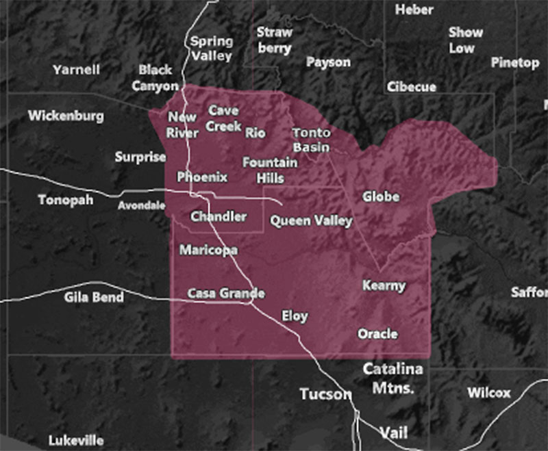
Issued Zones: Eastern half of Maricopa County … Pinal County … Southern half of Gila County …
Site: Arizona Weather Force has issued a Weather Advisory effective after midnight tonight through Wednesday morning …
Date: 8/2/22 at 2:45pm PT
Forecast: Severe thunderstorms in New Mexico will push westward into Arizona this evening. The ridge of high pressure will also press westward over the Payson forecast area and bring a small area of upper divergence to the advisory zone after midnight and through early Wednesday morning.
Showers and isolated thunderstorms will be the result. The best area to see these will be the Northern Pinal County zones through to about the Northeast half of Maricopa County, which would be Fountain Hills, Sunflower, Rio Verde, and Cave Creek.
The weakest thunderstorm dynamic in this advisory would likely be far west toward the edge of the advisory area in the Southwest half of Pinal County.
Still, this advisory means that showers and isolated thunderstorms are in the forecast in these zones …
Want these delivered to your e-mail and also the many other alerts for your area that area custom forecast for that you won’t see elsewhere? Sign-up for your free community paid for memberships for this season by going to this link – follow the terms of service directions as well – – https://arizonaweatherforce.com/?/register/BKNmp3
Join the Facebook Page for Further Updates If You Have Not Yet!
ARIZONA WEATHER FORCE MAIN:
Join The Main Arizona Weather Force Facebook Group (50 percent delivery time) – You can join the main AZWF page as well through that group.
Click Here To Join The Page Today
10 mile rule: These alerts issued on this site
means that within your zone and 10 miles from you will see the event
forecast for. You may or may not see the event but it means you are in
the zone or 10 miles from where someone will.
Master Meteorologist: Raiden Storm