Arizona Weather Force has issued an El Nino Watch effective now as conditions are fast developing for El Nino Conditions starting as soon as May so read on for details …
A moderate La Nina has faded over the last couple of months, with a replacement of warm water at the Equatorial Pacific. These conditions will continue to warm as we move through the rest of Spring.
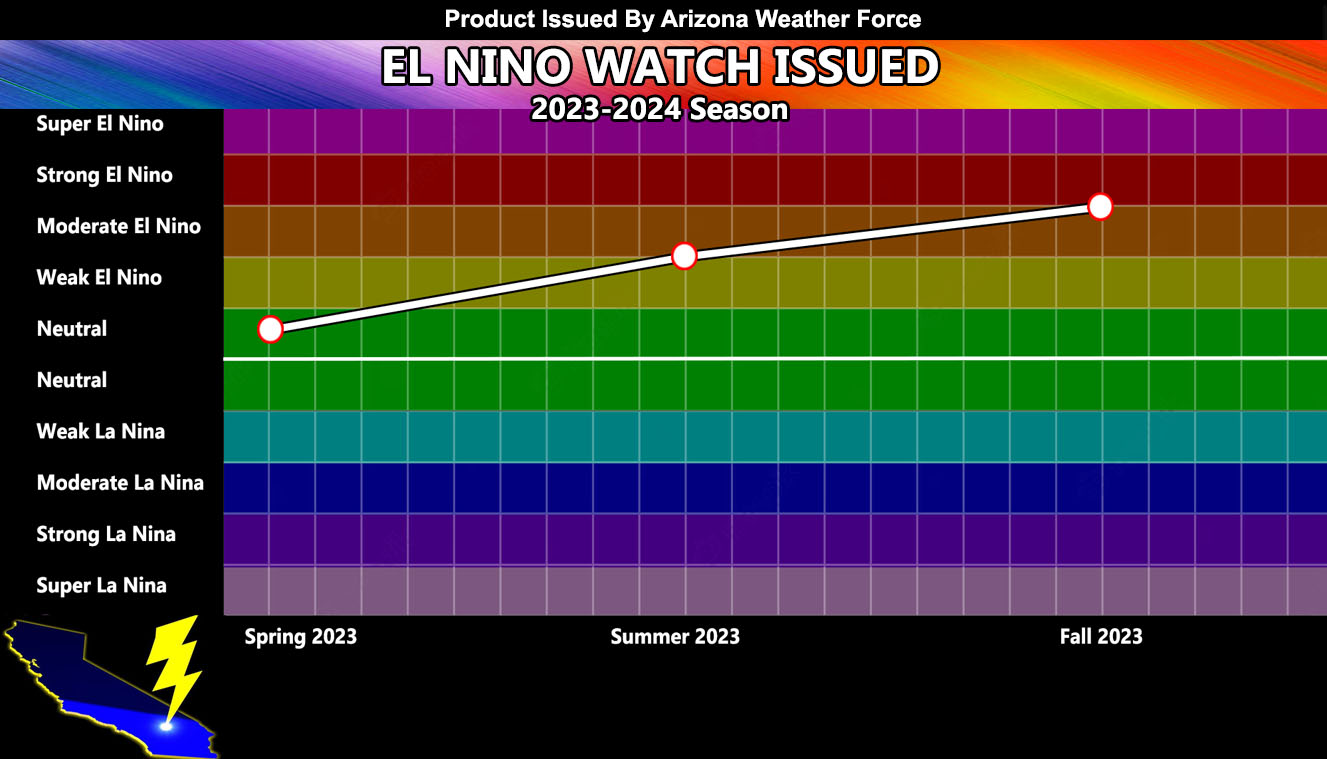
The Arizona Weather Force El Nino and La Nina model (pictured within this article) clearly shows an incline from Neutral to a Moderate El Nino by Summer 2023, owning toward the Strong El Nino category by Fall 2023, just on time for the next storm pattern into California.
Arizona Weather Force long range El Nino and La Nina models have been extremely accurate in the past. There is no doubt this will be an El Nino. The question is, will the atmosphere respond.
For this last season, the 2022-2023 storm season, all sectors of the weather industry said the La Nina conditions would bring drier than normal conditions for the Southwestern United States. My projection was the only one that put us above average in precipitation and below average in temperatures (Click here to read that). Given this, it is always important to be skeptical of long-range forecasts as they are very difficult. Planning these takes a lot of patience. While I am not anywhere close to projecting this next season’s Fall, Winter, Spring pattern for the 2023-2024 storm season in the Pacific Southwest, I can give the idea of Summer for the monsoon period within a month’s time, including the period of temperatures across California.
WHAT I CAN SAY: What I can say is that a fast developing El Nino can typically bring more hurricanes to the Eastern Pacific. The last time we had a strong signal like this was in the 1970s this brought a colder than average April, and a much hotter than average May. The concerns on this one for the monsoon is that I will start it this season at average, or equal chances. I will work more on that over the next month, but for right now due to some signals I am seeing, it will not break records like we saw the last two seasons have.
With vegetation growing across the region, we will also have a higher fire risk this summer due to summer heat as well. The onset of the monsoon always comes with high-based storms, which cause lightning sparked fires.
Stay tuned for additional information over the next month, but for now this forecast will be what I will be working with in the longer range.
Join the Facebook Page for Further Updates If You Have Not Yet!
ARIZONA WEATHER FORCE MAIN:
TWITTER: Join the AZWF Twitter For Articles By Clicking Here
Join The Main Arizona Weather Force Facebook Group (50 percent delivery time of micro-climate alerts not posted on the main AZWF page) – You can join the main AZWF page as well through that group.
Click Here To Join The Page Today