Arizona Weather Force has issued a Severe Thunderstorm Watch effective for the following zones. This is the final alert from the previous Severe Weather Statement issued yesterday for today.
Zones issued for: Mogollon Rim, including Payson through Prescott … Maricopa and Pinal County … Pima County, including Tucson.
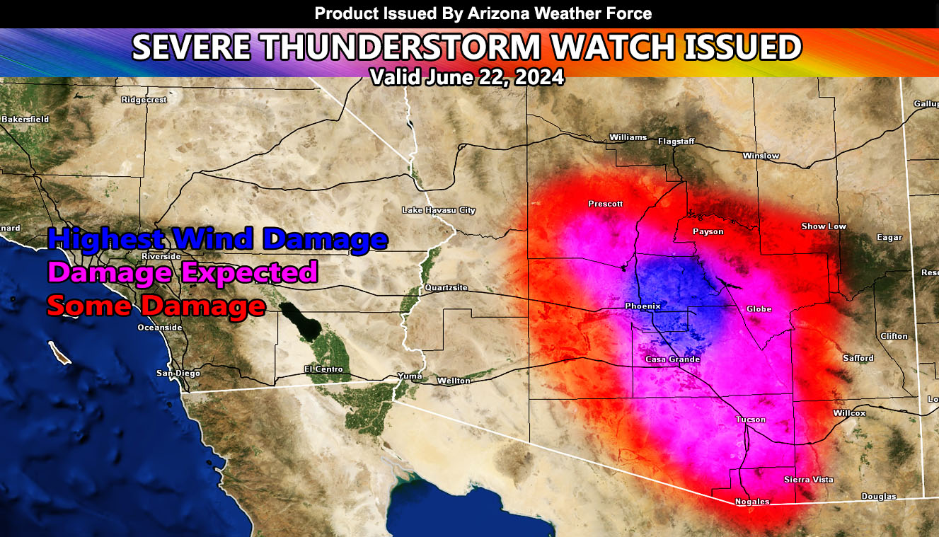
Eastern and Northern half of Maricopa County / Pinal County / San Tan Valley – You are considered my ground zero target for today’s damaging event.
Discussion: Thunderstorm development is expected by the early noon hours across the Show Low zones of the Mogollon Rim, with spreading activity developing near and south of Flagstaff and Prescott by early afternoon thereafter. Thunderstorm development will be the strongest in Northern Gila County, westward through Western Yavapai County along I-17. Temperatures in the low terrain zones will be well over 115F. This, combined with the cooler temperatures across the higher terrain is what will drive the damaging storm and outflow wind event southward to the metros. Payson, you’re also getting hit with severe thunderstorms today.
Storms will enter Maricopa and Pinal County toward the evening hours, which is always the case in storm situations like this.
At the same time, storms developing across Western Cochise County will send outflow and severe storms straight into the Tucson Metro zones.
Wind gusts with all storms within the lower terrain may reach up through 75+ mph, which will cause the most damage, as noted in the dark blue shade within the article map.
OVERNIGHT: Additional southerly impulses will be available for more storms OVERNIGHT TONIGHT into Sunday Morning
A Severe Thunderstorm Watch is issued as the final alert for the day, which will outline large hail, damaging winds, flooding, and/or tornado within the description itself.
SUNDAY: The activity focus will switch to Northwest Arizona, where Kingman is. Storm outflow jettisoning westward can reach the Havasu zones in the evening.
This is the final alert from the previous Severe Weather Statement issued yesterday for today.
Link to that – https://arizonaweatherforce.com/2024/06/21/severe-weather-statement-issued-for-arizona-metros-includes-phoenix-san-tan-and-tucson-june-22-2024/
– Raiden Storm –
https://www.arizonaweatherforce.com
Master General Meteorologist – is the Owner and CEO of AZWF, a consulting meteorologist with over 26 years’ experience for over 50 companies, including energy, agriculture, aviation, marine, leisure, and many more areas. He has certs from Mississippi State for broadcast met and Penn State forecasting certs MET 101, 241, 341 and 361 as a meteorologist, but before then was completely self-taught, barely learning a thing from the schools that he did not already know.
NOTE: Alerts are posted on here, be it a tornado watch, etc, and these alerts are issued from this office and nowhere else. At times, which is often, you will see an alert forecast posted on here that you do not see elsewhere.