Arizona Weather Force has issued a Special Weather Statement in response to the previously issued Long Range Weather Advisory issued a week ago for the return of the monsoon pattern across Arizona for mid-month.
Back on July 3rd, a Long-Range Weather Advisory was issued here at Arizona Weather Force that stated the following:
When Western Mexico ignites storms from tropical moisture like this, in the past these storms have been extremely powerful, owning up to sending outflow boundaries northwestward into Arizona. This looks to happen this month and Hurricane Beryl is to thank for it.
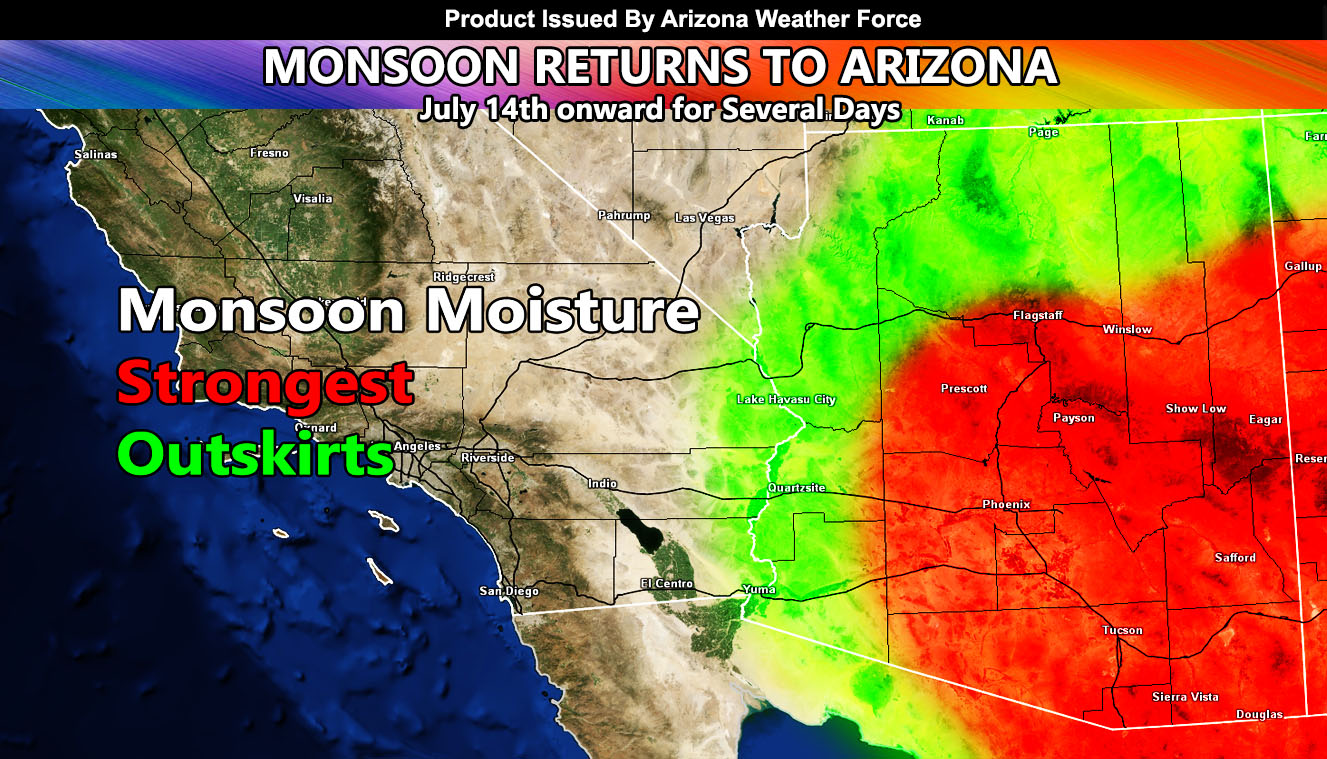
Arizona Weather Force models are showing an extreme and high risk for the main metro zones and Mogollon Rim locations. These zones, as shown on the Arizona Weather Force long range precipitation risk model are for Southeastern Arizona, including Tucson, Safford, Cliffton, Pinal, Phoenix, Gila, Mogollon Rim, and Prescott zones. Given the model shows notable as far as the California border, we can assume this is a major push of moisture, the strongest of this monsoon season thus far.
New Discussion: This statement issued for this event will be for that increase in monsoon activity that was expected here at Arizona Weather Force. We will see storms in Prescott and Sierra Vista today and more in Southeastern Arizona on Thursday, but that will be on pennies compared to the period between July 14th and 18th.
Strong upper dynamics and deeper moisture will be present during the statement period. Some of these storms will be pushed into the Tucson and Phoenix Metro zones, along with outskirts moving as far as the Colorado River Valley areas. Storms will contain the risk of flooding, large hail, damaging winds, and even a chance of tornadoes in the higher risk areas.
Arizona Weather Force is going to head the official weather watches and alerts for this event the morning of the severe storm alert as assertive from the Long-Range Weather Advisory issued beforehand.
Link to primary long range weather advisory issued on July 3rd – https://arizonaweatherforce.com/2024/07/03/long-range-weather-advisory-former-hurricane-beryl-remnants-to-elevate-arizona-monsoon-flow-mid-july/
– Raiden Storm –
https://www.arizonaweatherforce.com
Master General Meteorologist – is the Owner and CEO of AZWF, a consulting meteorologist with over 26 years’ experience for over 50 companies, including energy, agriculture, aviation, marine, leisure, and many more areas. He has certs from Mississippi State for broadcast met and Penn State forecasting certs MET 101, 241, 341 and 361 as a meteorologist, but before then was completely self-taught, barely learning a thing from the schools that he did not already know.
NOTE: Alerts are posted on here, be it a tornado watch, etc, and these alerts are issued from this office and nowhere else. At times, which is often, you will see an alert forecast posted on here that you do not see elsewhere.