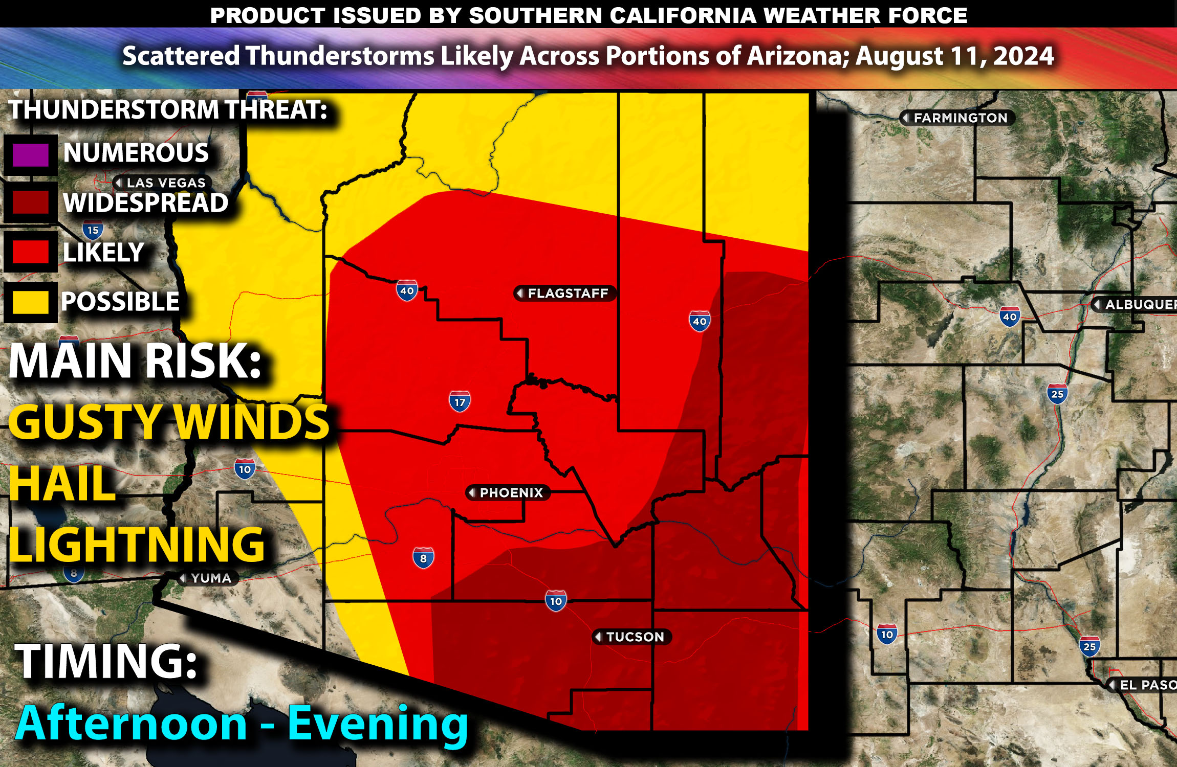
Brief Outlook:
Isolated to scattered thunderstorms are expected across parts of central and southern Arizona a few being strong/severe particularly in Maricopa, Pima, Pinal, Santa Cruz, and Cochise counties, from the afternoon into the evening. The main risk with these storms will be localized gusty winds, heavy rainfall, lightning and hail.
Counties and Cities Impacted: Maricopa County (Phoenix, Glendale), Pima County (Tucson), Pinal County (Casa Grande), Cochise County (Bisbee), Yavapai County (Prescott).
Upper-Level Forecast:
An upper-level shortwave trough will be moving across the western U.S., enhancing southwesterly flow aloft over Arizona. This setup will lead to increased lift and a favorable environment for thunderstorm development. The trough’s interaction with a persistent ridge over the region will create conditions conducive to stronger storms with possibly locally severe, with mid-level winds expected to range between 25-35 knots, providing enough shear to organize thunderstorms.
Surface Conditions:
At the surface, instability values are expected to reach 1000-2000 J/kg due to the hot and moist environment, with dewpoints in the low 60s. Effective shear will be moderate, supporting the development of discrete storms initially, which may then organize into clusters or lines. The steep mid-level lapse rates will support strong updrafts, capable of producing hail and localized wind gusts a few possibly locally severe. The moisture-rich environment will also contribute to heavy rainfall, with the potential for flash flooding in vulnerable areas.
Timing:
Thunderstorms are expected to initiate by early to mid-afternoon in central Arizona, with activity spreading into southern Arizona by late afternoon (more also forming with time). Overall, there will be pop corning storms all across AZ hit or miss fashion with the most concentration being the further south you are. Peak intensity will likely occur from late afternoon through the evening, with the most storms expected during this period. The storms are likely to diminish in intensity by late evening as the atmosphere stabilizes further with a few cells lingering further to the south of AZ.
Main Impact: gusty winds, heavy rainfall, and hail.
Sina⚡⚡
Managing Partner and Lead Forecaster of NWF Innovations & NWF Networks