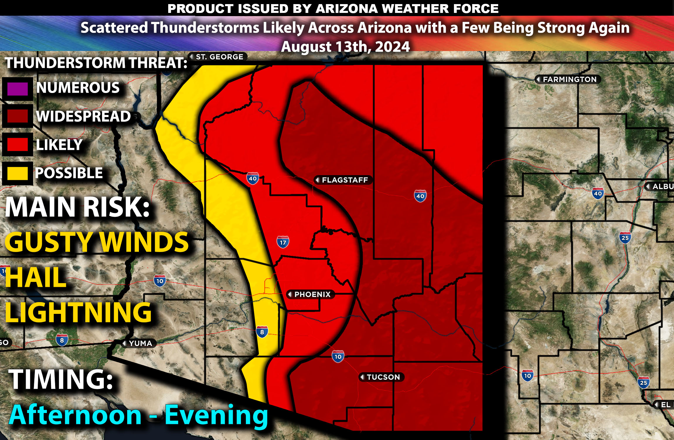
Brief Outlook:
More scattered thunderstorms are expected across central, northern and southeastern AZ with the concentration being from northeast towards the southeast less as you move westward. These storms are expected to form from the afternoon into the evening. The main risk with these storms will be once again gusty winds, flash flooding, and hail, with a few thunderstorms potentially becoming locally strong to severe just like Monday.
Counties and Cities Impacted:
Maricopa County (Phoenix, Mesa) (further eastward higher risk)
Pima County (Tucson)
Yavapai County (Prescott, Sedona)
Coconino County (Flagstaff, Page)
Cochise County (Bisbee)
Graham County (Safford)
Gila County (Globe)
Navajo County (Holbrook)
Greenlee County (Clifton)
Apache County (St. Johns)
Santa Cruz County (Nogales)
Upper-Level Dynamics/Forecast:
An upper-level shortwave trough will continue moving across the southwestern U.S., bringing enhanced southerly flow aloft over Arizona. This interaction will lead to increased lift and instability, providing a favorable environment for thunderstorm development. Mid-level winds are expected to range between 20-30 knots, providing moderate shear that can help organize stronger thunderstorms, particularly in the afternoon and evening hours.
Surface Conditions:
At the surface, instability values are expected to reach 1000-1800 J/kg due to the hot and humid conditions prevailing across Arizona from the monsoonal flow. Dewpoints in the upper 50s and low 60s again will contribute to a moist and unstable atmosphere, priming the region for thunderstorm activity scattered across AZ especially north/eastern AZ. Effective shear will support the initial development of discrete storms, which may organize into clusters as they progress but mainly staying scattered in popcorn fashion. The steep mid-level lapse rates (change in temperature with height) will promote strong updrafts, increasing the potential for locally strong to possibly severe storms capable of producing microbursts and hail hit or miss. The presence of monsoonal moisture will result in heavy rainfall with a risk of flash flooding, especially in areas with poor drainage, recent burn scars, and locations where storms tend to train over.
However, the weather pattern is expected to change, becoming more stable with significantly less thunderstorm activity if any on Wednesday as the monsoonal moisture pulls back.
Timing:
Thunderstorms are expected to initiate by early to mid-afternoon across central Arizona, with storms popping up like popcorn across the highlighted regions by late afternoon. Although the Phoenix area is not the main area of concern, it may still experience a pop-up storm or two. However, the primary activity will be further north, south, and east of Phoenix. Peak intensity will likely occur from late afternoon through the evening, with the strongest thunderstorms expected during this period. The storms are likely to weaken by late evening as the atmosphere stabilizes for the most part. However, a few storms may linger before diminishing overnight in areas where the airmass remains slightly less stable.
Main Impact: hail, flash flooding, gusty winds, and lightning.
Stay tuned for more updates.
Sina⚡⚡
Co-Owner/CTO and Lead Forecaster of NWF Innovations & NWF Networks