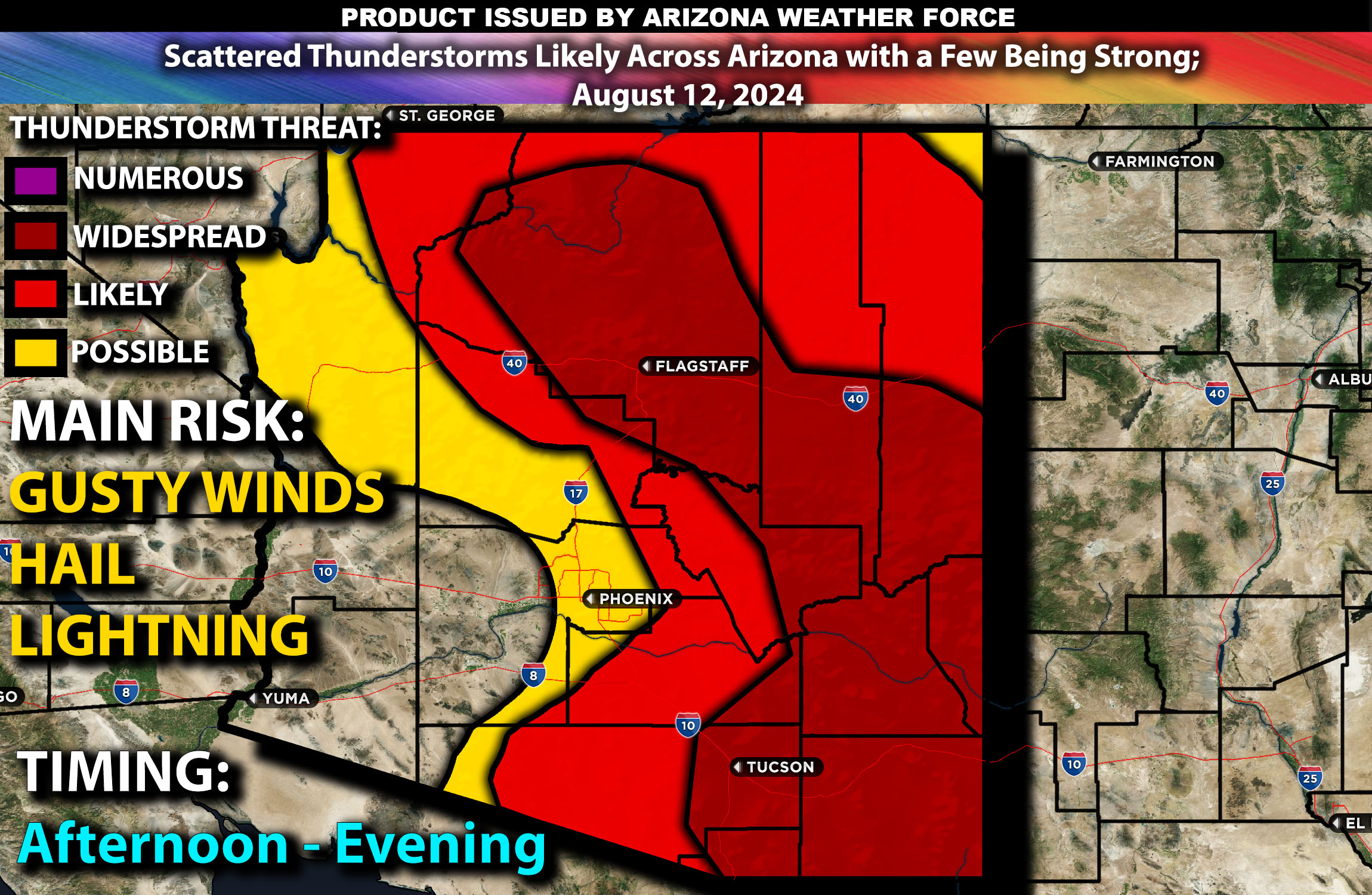
Brief Outlook:
Scattered thunderstorms are expected across Arizona, with activity concentrated in central/northern and southern regions (especially southwest). More popcorning storms expected again across the Flagstaff region with more cells to the central east and southern portions of AZ especially. The main risk with these storms will be strong gusty winds, flash flooding, and isolated hail, with a few thunderstorms potentially becoming locally strong to severe capable of large hail/microbursts.
Counties and Cities Potentially Impacted:
Maricopa County (Phoenix, Mesa, Glendale)
Pima County (Tucson, Oro Valley)
Yavapai County (Prescott, Sedona)
Coconino County (Flagstaff, Page)
Cochise County (Bisbee)
Graham County (Safford)
Gila County (Globe)
Navajo County (Holbrook)
Greenlee County (Clifton)
Upper-Level Forecast:
An upper-level shortwave trough will move across Arizona, interacting with a subtropical ridge over the Four Corners region. This interaction will enhance southerly flow aloft, providing lift and promoting thunderstorm development. Mid-level winds, expected to range between 20-30 knots, will create moderate shear that can help organize stronger thunderstorms. The combination of these factors will make the atmosphere conducive to thunderstorm activity, particularly during the afternoon and evening hours.
Surface Conditions:
At the surface, instability values are expected to reach 1000-2000 J/kg due to the hot and humid conditions prevalent across Arizona. Dewpoints in the upper 50s to low 60s will contribute to a moist and unstable environment, priming the atmosphere for thunderstorm development, with a few cells likely becoming strong. Effective shear will support the initial development of discrete storms, which may organize into clusters or lines as they progress over time. The steep mid-level lapse rates will promote strong updrafts, enhancing the potential for locally strong to severe storms capable of producing gusty winds and hail. Additionally, the abundant monsoonal moisture will result in heavy rainfall, raising the risk of flash flooding, particularly in areas with poor drainage, recent burn scars, and where storms tend to train over.
Timing:
Thunderstorms are expected to initiate by early to mid-afternoon across central and northern Arizona, with scattered activity also anticipated across southern portions of the state by late afternoon. These storms will then move north to north-northwestward across the region in a hit-or-miss manner. A few storms may also move east of the Phoenix area; however, the concentration of storms will be more towards the east, south, and towards the Flagstaff area. Peak intensity will likely occur from late afternoon through the evening, with the strongest thunderstorms expected during this period. The storms are likely to weaken by late evening or overnight as the atmosphere stabilizes.
Main Impact: hail, flash flooding, gusty winds, and lightning.
Stay tuned for more updates.
Sina⚡⚡
CTO and Lead Forecaster of NWF Innovations & NWF Networks