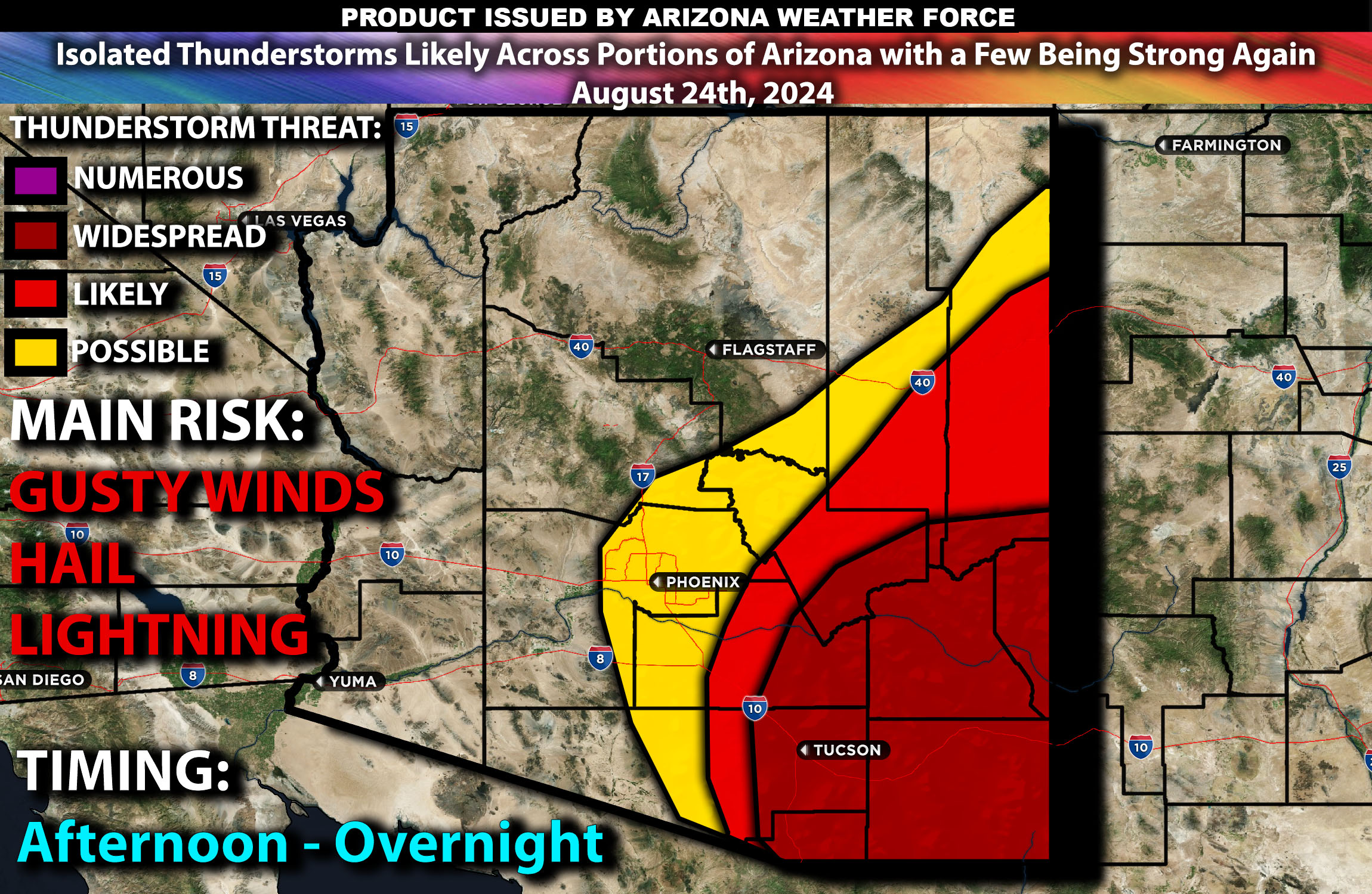
Brief Outlook:
Isolated thunderstorms are expected across parts of Arizona today with a few being strong, particularly affecting central and southern regions. These storms will be capable of gusty winds, hail, lightning and localized flash flooding.
Region Impacted: Central and Southern Arizona
Counties and Cities Impacted (hit or miss):
Cochise County, Arizona
Graham County, Arizona
Greenlee County, Arizona
Pima County, Arizona
Pinal County, Arizona
Santa Cruz County, Arizona
Gila County, Arizona
Maricopa County, Arizona
Upper-Level Dynamics:
An upper-level shortwave trough is progressing across the southwestern U.S., creating conditions favorable for thunderstorm development across portions of Arizona. The upper-level winds, ranging from 20-30 knots, will help support the organization of thunderstorms as the day progresses. This setup, combined with the presence of a subtropical ridge to the east, will increase the chances of storms in the region especially southeastern portions.
Surface Conditions:
At the surface, instability values are expected to reach 1000-2000 J/kg due to strong surface heating and ample moisture, with dewpoints in the low to mid 60s. This will create a conducive environment for thunderstorm development, particularly in central and southern Arizona. The presence of moderate effective shear will support the development of discrete storms initially, with a tendency for storms to organize into clusters or lines as they move through the region. Mid-level lapse rates are expected to be steep, promoting strong updrafts capable of producing large hail and damaging wind gusts. Localized flash flooding is also a concern, particularly in areas with poor drainage or recent burn scars.
Timing:
Storms are expected to initiate by early afternoon (around 1-3 PM MST) in southeastern Arizona east portions of Tucson, with activity increasing across portions of southeast/central regions by late afternoon. An isolated thunderstorm is possible and more likely east of Phoenix as well during the afternoon with most activity further southeast. Peak intensity is likely to occur from mid-afternoon through the evening, with the strongest thunderstorms expected during this period. These storms will be moving north north-east. Storms are likely to weaken by overnight as the atmosphere stabilizes.
Main Impact: strong winds, localized hail, localized flash flooding and lightning.
Stay tuned for more updates.
Going forward, outlooks will be posted the evening before with watches/warnings during the day of the event.
Sina⚡⚡
Co-Owner/CTO and Lead Forecaster of NWF Innovations & NWF Networks