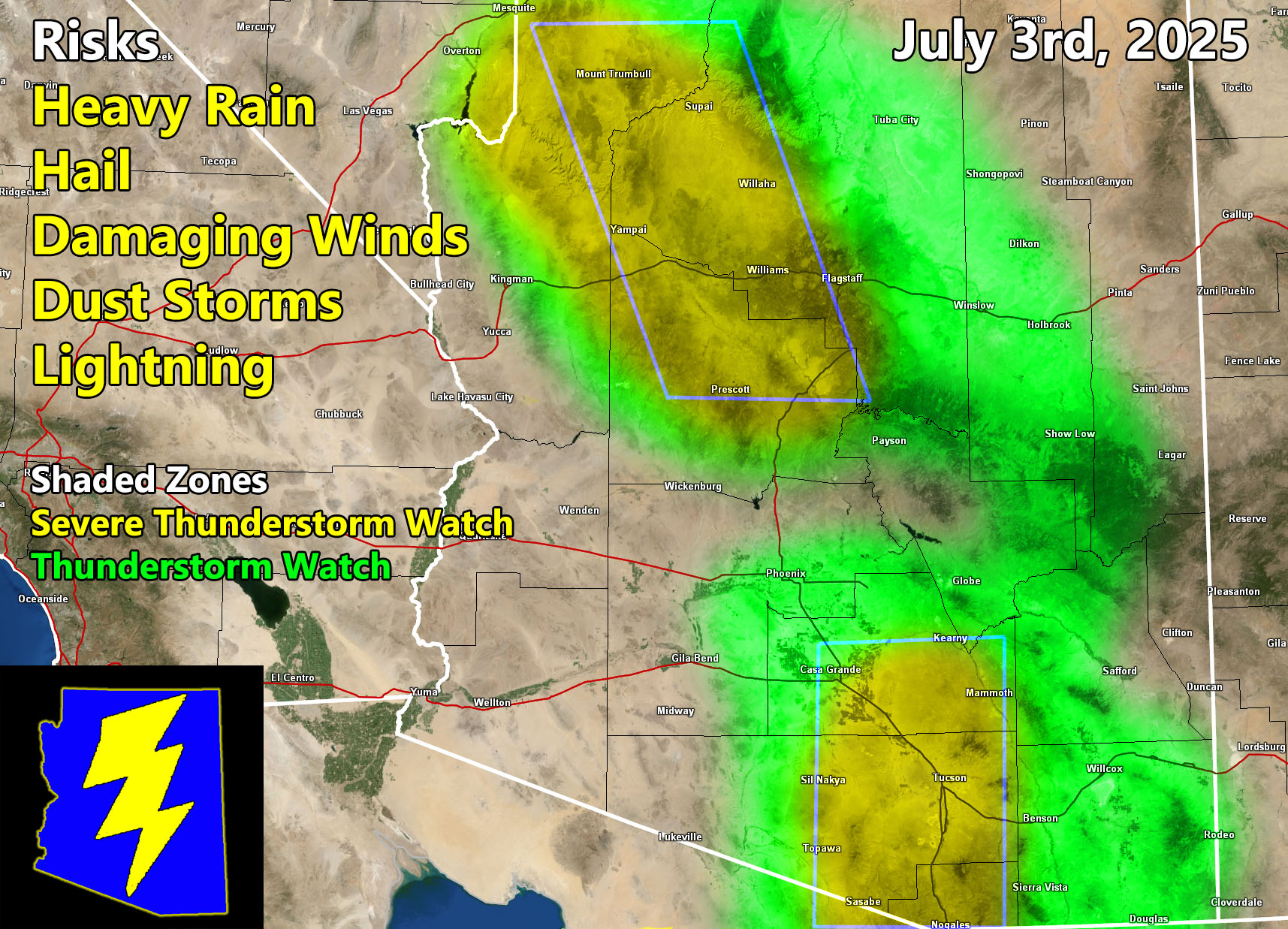
Arizona Weather Force has issued a Severe Thunderstorm Watch and Thunderstorm Watch, effective Thursday, July 3rd, 2025, for the following zones;
Issued Zones: Pima, Pinal, Maricopa, Yavapai County, Santa Cruz, Cochise, and Gila County … Mogollon Rim … Flagstaff to Grand Canyon … Western half of Graham County … Winslow/Snowflake/Holbrook
Date Issued: July 3rd, 2025 at 9:15am PDT
Discussion: Instability is developing once again across Arizona, which should be the last day before a monsoon pattern break for many areas as we gain those summer temperatures once again in the elevated above normal positions. There are two Severe Thunderstorm Watches issued, with different areas being affected. The first one is for Yavapai County, Flagstaff, and the Grand Canyon areas. Damaging winds, Large Hail, and even isolated tornado activity can be possible given the passage of the trough axis (upper-level low). The second area is down inthe Tucson Metro zones. Thunderstorms will explosively develop once again in that zone, owning to the damaging wind/hail risk as well. Some of the storms with outflow will be sent into Pinal County.
Now, the interesting dynamic will be whether we get storms forming southwest of Phoenix today. There is an upper-level dynamic that will be moving through, with good divergence (lift) over the mountains southwest of Phoenix and west of the city of Maricopa (Why in Pinal? lol) … Given the east to west flow this afternoon and evening for this zone, any outflow and pop-up storms would result from there through Phoenix to San Tan/Mesa and around that small zone of the county, which is shaded in the green-shade for this forecast. Thunderstorms will also be expected across the White Mountains, north into the Snowflake/Winslow forecast zones as well. Disorganized pop-up storms will be likely for most of Navajo/Apache County, even if you are not in a shaded zone. The green shade is for more organized focus spots.
A Severe Thunderstorm Watch is issued at Arizona Weather Force when conditions are possible for severe thunderstorms, covering over 50% of the watch zone, with damaging winds of over 50 mph and large hail in the stronger storms. Severe Thunderstorm Watches at Arizona Weather Force are private, issued ahead of time to the public by AZWF as the lead-time is extremely important to you.
A Thunderstorm Watch is issued at Arizona Weather Force when conditions are possible for thunderstorms, covering 50% of the watch zone. Thunderstorm Watches at Arizona Weather Force are private, issued ahead of time to the public by AZWF as the lead-time is extremely important to you.
Raiden Storm
Master General Meteorologist