Arizona Weather Force has issued a Thunderstorm Statement effective Monday to Tuesday Morning, September 1st into 2nd, 2025 for the following zones;
Issued Zones: Yavapai, Maricopa, Pinal, Graham, Greenlee, and Gila County … Mogollon Rim … La Paz and Yuma County …
Date Issued: September 1st, 2025 at 11:00am Local
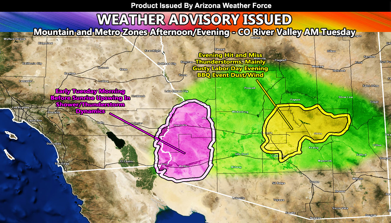
Discussion: Arizona Weather Force is going into a supercharge high resolution forecast mode now that we are within the Long Range Weather Watch window of the first half of September becoming more active in terms of storms and gusty/damaging outflow winds. For today, the Thunderstorm Statement that was issued yesterday will be finalized as a weather advisory, meaning mostly hit and miss thunderstorm activity. Here is how it will go. Thunderstorms will form in the High Terrain across the Mogollon Rim, west through the Prescott forecast zones this afternoon. The outflow from them will be sent downhill into the Metros. Based on the severity expected, the strongest storm will be in Gila County.
This means that a due east to west flow would send that storm’s outflow west to the Eastern half of Maricopa County, and the North to Northwest half of Pinal County. This includes Fountain Hills, Apache Junction, San Tan Valley, and the Mesa forecast areas. Hit and miss thunderstorms will be expected in those areas this evening, but what will hit everyone in those areas will be the strong outflow winds and dust, reducing visibility on travel. Outside BBQ activities will be affected, so get the dinner ready early on.
COLORADO RIVER VALLEY: The same outflow will be moving through Western Arizona overnight. An addition to that, an easterly wave moving out of Mexico will reignite thunderstorm activity from the La Paz County zones southward to Yuma early Tuesday morning, even before sunrise. So you will get to see lightning during the dark within the morning hours on Tuesday.
This is about it for the dynamics of today. Tomorrow’s forecast will be updated accordingly, which looks like the aim is also for Kingman’s forecast zone as storms will move from east to west off the convergence zone to your east.
A Weather Advisory is issued at Arizona Weather Force when hit and miss thunderstorms are expected. Additional information such as dust storms or gusty winds will also be introduced within the alert. Alerts at Arizona Weather Force are private, issued ahead of time to the public by AZWF as the lead-time is extremely important to you.
Raiden Storm
Master General Meteorologist