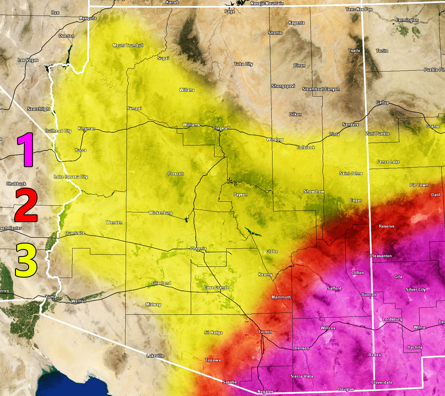
Arizona Weather Force is releasing a three part discussion so that it can answer some questions on what to expect across the state for Thursday through Friday. You will need to read the entire numbered paragraphs and know where you are within the map. The number key on the map is where your discussion is so let’s begin.
Section 1 – This is where the deepest moisture will be hitting. On a weakening trend, Hurricane Lorena will get wider, bringing a swath of tropical moisture through Mexico and into the Southeastern half of Arizona. Section one is where I expect some wind and most importantly the flooding. This is considered the ‘gentle’ zone in terms of the lack of severe thunderstorm activity. It will be a prolonged period of flooding rains with less in the way of severe thunderstorms. Still, this section will be the one for prolonged flooding conditions later Thursday and going through Friday. Over 3-6″ of rain will be likely in this section.
Section 2 – This fine line from Southern Arizona, stretching through Tucson and up through the Northern half of Graham and Greenlee County … will be where it will be both section 3 and 1 dynamics. This means that both explosive and dangerous severe thunderstorms with large hail, damaging winds, and flooding will all be possible. This is most likely in Tucson for Thursday afternoon and evening, followed by the section 1 prolonged rainfall dynamic Thursday night through Friday. Basically in section 2 you will get a mixed bag of dangerous weather dynamics.
Section 3 – This large area is mainly for Thursday’s focus. Out ahead of Lorena’s center, strong instability with deep moisture in place will provide severe thunderstorm development. These will not be like section 1. You will not get prolonged flooding with a little wind. These storms will be of the numerous severe thunderstorm type cells that will bring damaging winds and large hail , in addition to flooding. Storm motion will be east to west, so the convergence zones across Pinal/Maricopa/Yavapai County look prime, with Maricopa County seeing the most damage from severe storms on Thursday’s outlook. Just because you are not in the flooding zone as Section 1 is, does not mean that numerous severe thunderstorms hitting one after another is something to ignore. The flooding will be high risk as well, especially Maricopa County. I expect high risk flooding in that area. Severe storms will also affect Kingman to the CO River Valley zone’s Central and Northern parts as well as Flagstaff and the Mogollon Rim / White Mountains this day.
Updates will be made as we go through the event, but this is the outlook for the event in sections, so hope you can read and understand it right as it was broken down as much as possible.
Raiden Storm
Master General Meteorologist