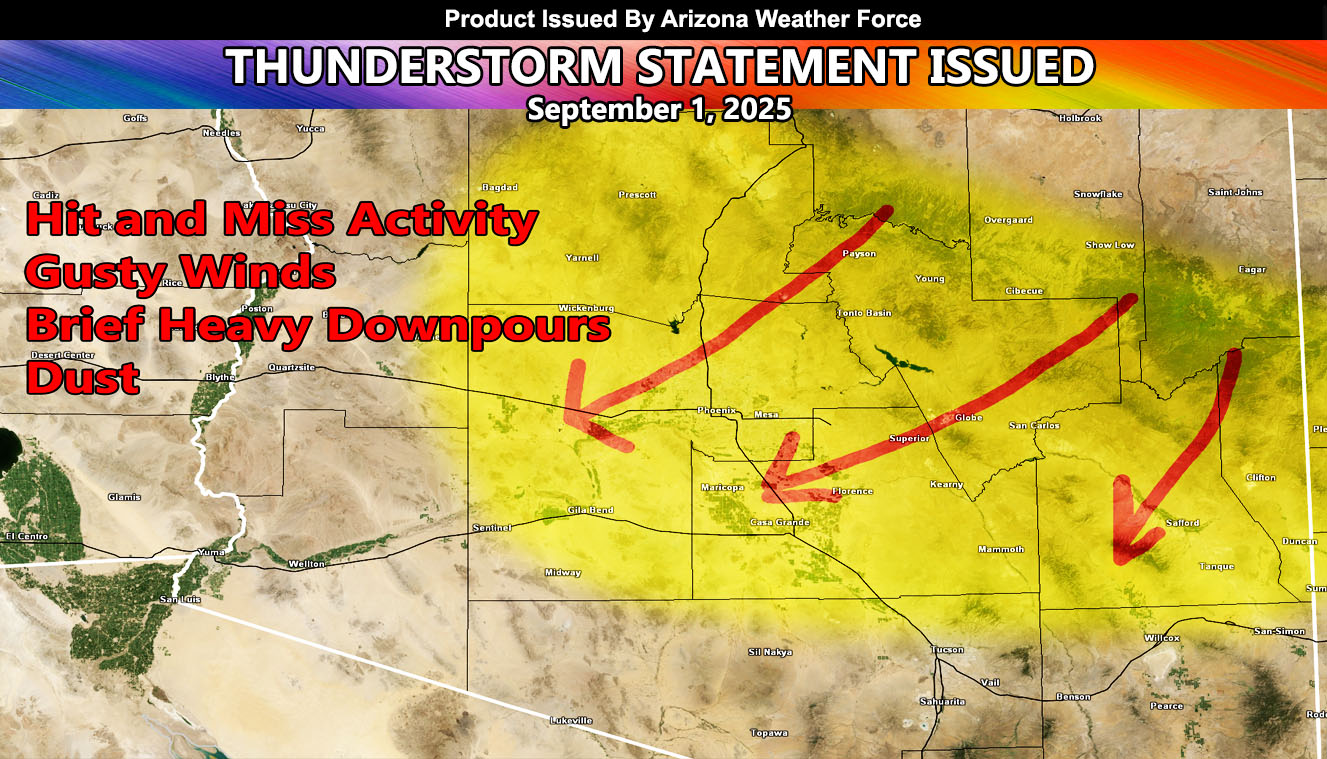
Arizona Weather Force has issued a Thunderstorm Statement effective Monday, September 1st, 2025 for the following zones;
Issued Zones: Yavapai, Maricopa, Pinal, Graham, Greenlee, and Gila County … Mogollon Rim …
Date Issued: August 31st, 2025 at 2:40pm Local
Discussion: A ridge of high pressure that has developed over Gila County today will shift north. This ridge of high pressure has a northeast to southwest flow on the southern end of it today, which is why Arizona Weather Force went full Thunderstorm Watch (not posted on social media) for Southeast Arizona’s Cochise and Santa Cruz County. Those of you in Sierra Vista, you are at or near the center of these dynamics later on this evening or night, which can be viewed at Reference A below.
As for this statement. These are second in line to the final alert, which would be issued the day of. Thunderstorms are expected to develop across the High Terrain north and east of Phoenix and Pinal by the afternoon hours. This will shove south and eastward off them, with strong outflow winds. The current thinking is that the outflow will be strong enough for pop-up hit and miss thunderstorms across Maricopa and Pinal County during the evening hours. Not everyone will see it, hence the wording hit and miss. Those that do, gusty winds within the thunderstorm outflow and downdraft will be most likely along with brief heavy downpours.
Storms are expected to move from north to south across Greenlee and Graham County as well, which puts Safford’s forecast zones in a chance of activity during this period.
Areas not within the watch, but an honorable mention will be west of Maricopa County, for the La Paz regions. Should the outflow of Maricopa County’s evening storms be strong enough, pop up shower/thunderstorm activity will be possible overnight in that zone.
Arizona Weather Force will monitor the system on Monday morning, and bring you the final alert if needed.
Reference A – August 31, 2025 Thunderstorm Watch for Southeastern Arizona
Link – https://arizonaweatherforce.com/2025/08/31/thunderstorm-watch-for-santa-cruz-and-the-southern-half-of-cochise-county-centering-sierra-vista-august-31-2025/
A Thunderstorm Statement is issued at Arizona Weather Force a day before the expected event. Thunderstorm Statements issued means that a Thunderstorm Watch or Weather Advisory zone is pending for release the morning of the event spoken of and that additional information will be given on the final. Alerts at Arizona Weather Force are private, issued ahead of time to the public by AZWF as the lead-time is extremely important to you.
Raiden Storm
Master General Meteorologist