The Arizona Weather Force Rainfall Forecast has been released and it is valid through Tuesday. The AZWF Thunderstorm Watch issued yesterday evening for today has officially begun, and it will go through till sunset. Read on for details.
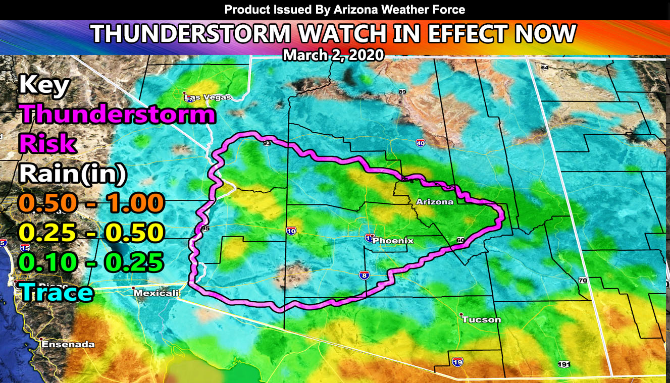
Self explanatory on the rain model. There is a key that shows the thunderstorm risk zone for Monday as well as the rainfall amount expected. Keep in mind that although lower numbers are showing up in spots where the thunderstorm watch is located, these are hit and miss and you may see it or you may not. Given the atmospheric profile and upper low position for divergence, do feel that the Western Phoenix Valley will not be left out like you were in other systems.
There are convective cells forming first, just east of the CO River Valley Parker/Lake Havasu City areas. The backing east flow has begun, a bit late, but it is there. You may see thunderstorms popping up early this morning first as instability has already begun with the steepening lapse-rates from the cold-core low moving in.
As the morning moves along into the afternoon, developing instability will ignite scattered thunderstorms across the Western half of Arizona. They will extend as far northeast as Payson. They also will affect some of the Phoenix Valley. Like usual, these are hit and miss storms so not everyone will see it. You will hear of a neighboring city having storms while you don’t see anything. It’s quite common with these setups.
Instability will be weaker than severe storm criteria so I do not expect severe thunderstorms with this. These will however bring some gusty winds and small hail under the strongest cells.
The cells will die with the setting Sun as instability is lost. On Tuesday, we will be looking for the risk of thunderstorms in far SE AZ surrounding the Clifton forecast zones. The micro-climate alerts via e-mail will take care of that area.
As stated days ago, after March 1st we would see such a system move in. As it gets closer then I will assess the rain/snow risk and produce those numbers to you. Furthermore as stated in the previous article (Read here), and I quote it “MEDIUM RANGE: Our next system comes in After March 1st so yes… it will rain again across the state, and there are indications that MARCH 2020 will have above average rainfall for Arizona in my preliminary numbers … ” and that happens just after March 8th, right on schedule for the rainy month forecast.
As you know, just as Southern California Weather Force has a service for members with micro-climate alerts, Arizona Weather Force does as well and we do have some people already signed up getting those so it is seeming like it is helping. The service helps businesses and persons, especially with ranches. Click Here to read about it and even join.
NOTE: This is the SCWF Website but it is being used for national updates until ad placement is ready on the AZWF site.
Your Facebook Page to join for this update is linked here – https://www.facebook.com/ArizonaWeatherForce