Every beginning month or so I’ll issue a monthly forecast. You can view August’s forecast here at this link. We can note that it did extremely well, even predicting the end month activity we just saw.
Here’s the link again – https://www.facebook.com/ArizonaWeatherForce/posts/635466727846107
September is cutoff low season. It is the season where many think the monsoon will be ramping down, but in reality September has been known to excel the monsoon across the Desert Southwest. The reason for this is because as you know, the Earth is titled and that is how we get seasons. Meteorological Fall started today, September 1st. It is different than astronomical fall, which is a few weeks from now. In weather, we go by meteorological fall due to the changing of the weather during the month of September. As the northern skies start to darken and days become short, the North Pole starts to cool rapidly during this month and into October. The jet stream is controlled by this. The movement of the jet stream is because of the temperature difference between Alaska and our area’s latitude. During the summer, this isn’t too much of a difference because the north is in full sunlight. But as Fall hits, the north becomes cooler as we remain warm. This contrast in temperatures activates the polar jet stream and makes it become erratic, moving further south into the United States. This is when Washington State sees their strongest storms as well. At times, this jet stream buckles under an omega block and sends an upper-level low down the West Coast. This is cutoff low season for us. Cutoff lows during the monsoon do three things for us.
- The cutoff lows place themselves west of both Southern California and Arizona. If monsoon moisture is deep in Mexico, this low would pull it northeast for a revamp in the monsoon. It even is enough to push deep moisture into California.
- The cutoff system is in the same area, pulling in moisture from a traveling hurricane south of the United States, much like where Hurricane Linda last month was crossing. This would produce severe weather across both regions of SoCal and AZ.
- The cutoff system is further west under the base of a stronger trough and any traveling hurricane south of the area would be rapidly pulled northward and overspread precipitation across the entire Southwestern United States.
This year, we are looking at either 1 or 3. I do not see a repeat of 2019’s pattern for September. What that means is, between September 7th and the middle of the month, maybe a 7-10 day pattern … the last breath of the monsoon ridge would bring in monsoon moisture from Mexico, through Arizona and into most of California. This could be beneficial for fires there if the moisture is deep enough. If not, we will have even more fires in California as a result of this pattern to come. September is generally when we do still see active hurricanes developing in the Eastern Pacific Basin. We should still see development of such as this is still and has been a very active season down there, and it won’t shut off till at least sometime in October. Any system would be pulled northward west of Baja and provide the dynamics for storms across California and Arizona.
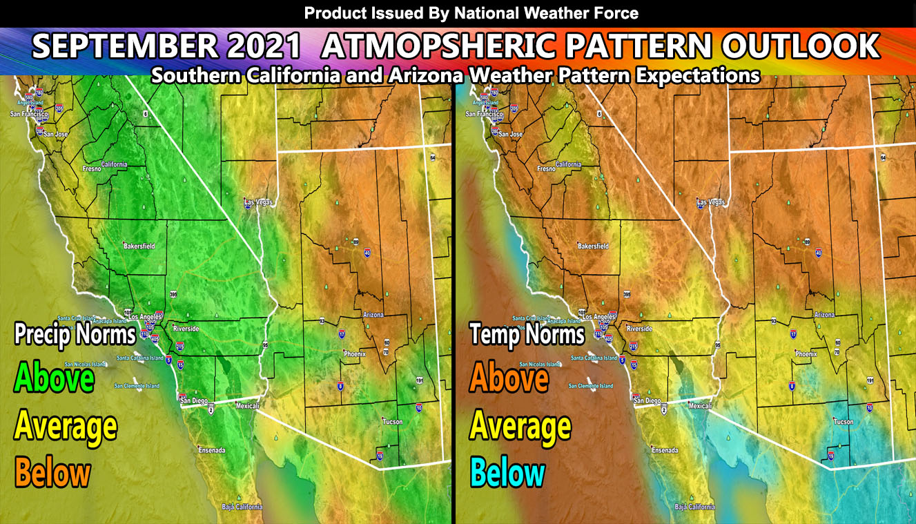
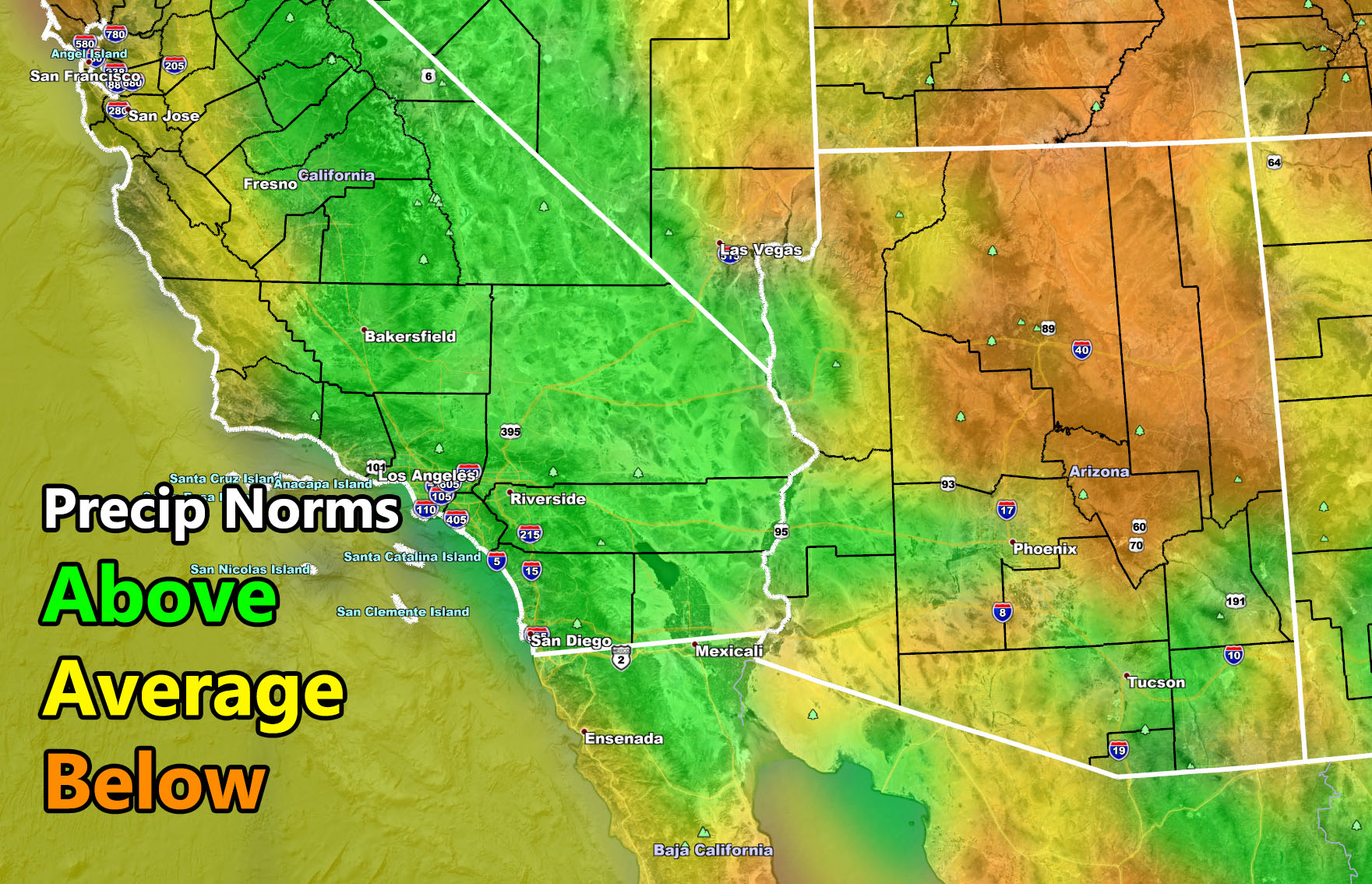
As such, embedded in this update is are two images. These images show as a result of the pattern the precipitation and temperature departure from average. One thing I am noting is the moisture in Mexico on the map, moving through the southern half of Arizona and into most of California. This would match scenario 1 above where a cutoff system would be west of Southern California combined with the monsoon ridge north of Arizona, pulling in deep moisture across the region between September 7th and maybe the 17th or so, around that window.
Give that pattern, the beginning and middle part of the month would need to be monitored for more precipitation in both SoCal and Arizona with indications that California could finally see some bit of relief from the parched Summer it had vs the major monsoon season Arizona has had. As a result of this, mostly average temperatures are expected in the region, with above average in the SoCal Deserts and the northern half of Arizona. Tucson would be below average for the month due to the forecast of increased monsoon moisture and humidity at the surface, keeping temperatures below the monthly average.
SEASON FORECAST: For September, October and November … There are indications that this season will only get stronger in the Southwest United States. Generally I still think we will get close to a weak La Nina but I do not think we will stay there for long. I still think we will hover just outside those limits so remaining a neutral season, a LA NADA or neither La Nina or El Nino showing up. Washington State should get a lot of rainfall, but as a result of them getting the rain, us down here also will benefit from the storm systems coming through so I do think between September, October, and November that all of the forecast areas from California, Nevada, and Arizona will have above average rainfall before November is over.
HERE ARE THE IMAGES IN THE ARTICLE UPDATE SO YOU CAN CLICK THEM TO VIEW A LARGER VERSION –

As always, Stay tuned to Arizona Weather Force for future updates –
BONUS: For a bit of time I will allow non-members to see the member section of AZWF. During Fall, Winter, and Spring, the member section has zoom in models during events predicted. They are placed there in the tabs, this one is the heat model. It contains a zoom-able model so you know where you are on the map. Better yet, members can enter a city and address in the search bar and it zooms right down into that level. This is a medium resolution map, the other ones AZWF has at disposal have higher resolutions available during storm events from rain, wind, snow, and flood.
CLICK HERE TO ENTER THE MEMBER SECTION TO TRY IT OUT. Note, this does not include the e-mail alert system, just the visuals of the models provided.
If you like it… Click Here to become a full member and get those zoom in models + the e-mail alert system where you choose zones to receive custom alerts.
Get these alerts via your own e-mail control panel for your zone at 100% where social media IS NOT, or the closest to you as a full supporting member of this service that saves lives and property – here – https://arizonaweatherforce.com/azwf-discount-member-sign-up-page/
Join the Arizona Weather Force group for photos and pictures, and sometimes updates not posted on the main FB Page – here – https://www.facebook.com/groups/arizonaweatherforecasts
See ALL Active articles and alerts for Arizona here – https://arizonaweatherforce.com/
Arizona Weather Force is a custom weather alert service that began in September 2019 off of Southern California Weather Force and is regarded as the most accurate weather service in the state, offering custom alerts, maps, and models to help save life and property. The work done here is never 100% accurate, but it comes pretty close. Arizona Weather Force runs on zones, so if an event happens in a zone that is 10 miles from the border of your zone, the forecast is still valid to activate your zone’s alert system. A company quote to the public is that of “The Joker” and tells other agencies in weather this all the time… “This world deserves a better class of meteorologist… and I’m gonna give it to them”… out-forecasting even the National Weather Service with lead-time and precision, which makes this service a focus of ridicule and envy in the weather community due to having such accuracy. Alerts issued here are issued custom from this office and this office alone. You may not even hear it elsewhere, but if one is issued near or in your area, listen up because “if you do not wish to die in weather, follow, it’ll save your life one day.”
Meteorologist In Charge – ![]()
![]() – is a consulting meteorologist for over 50 different companies, including large oil companies like BP. He has certs from MSU and PSU as a meteorologist. Both short and long-range is very important to know in those jobs so you can bet on accuracy here. He is versed in fields like Western USA, Tornadoes, Floods, Hurricanes, High Winds, Fire Behavior, Snow and Blizzards, Short Range, Long Range, Seasonal, and Life-Threatening decisions with over 20 years experience, out-forecasting even the National Weather Service with lead-time and precision, which makes him a focus of ridicule and envy in the weather community due to having such accuracy.
– is a consulting meteorologist for over 50 different companies, including large oil companies like BP. He has certs from MSU and PSU as a meteorologist. Both short and long-range is very important to know in those jobs so you can bet on accuracy here. He is versed in fields like Western USA, Tornadoes, Floods, Hurricanes, High Winds, Fire Behavior, Snow and Blizzards, Short Range, Long Range, Seasonal, and Life-Threatening decisions with over 20 years experience, out-forecasting even the National Weather Service with lead-time and precision, which makes him a focus of ridicule and envy in the weather community due to having such accuracy.