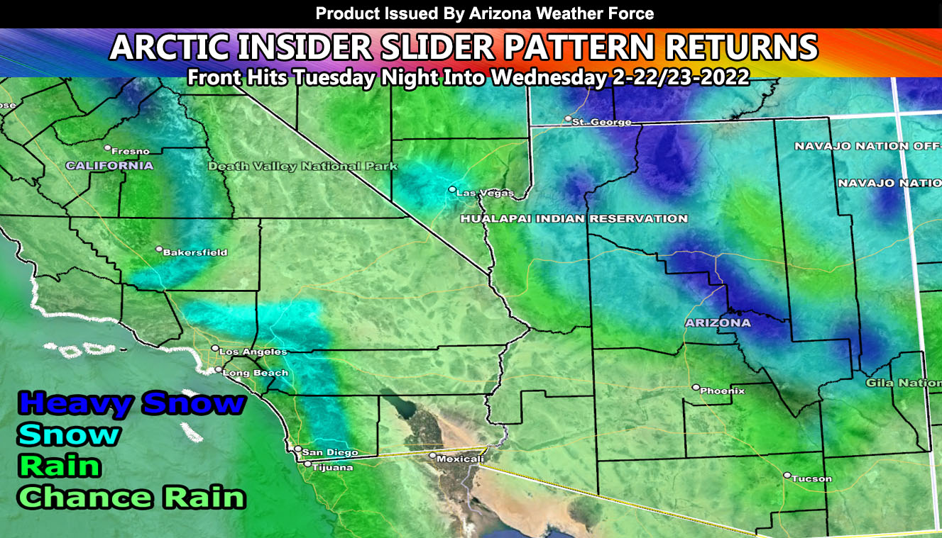
Arizona Weather Force has issued a Special Weather Statement for a near repeat weather pattern from several days ago with lower snow-levels, gusty winds, and rainfall in an inside slider fashion with heavier snowfall for the Mogollon Rim, including Payson, Prescott, and Flagstaff and rain in the lower terrain so read on for details …
The last storm system was completely nailed and as you saw in the final forecast article, sometime after February 20th would be the next pattern start. This looks to happen with an onshore flow and gusty winds as early as Monday in the mountain areas followed by the rest of the state Tuesday into Wednesday.
As Tuesday night hits, the frontal zone will drop the snow-levels down below 4,000 FT, in some cases below 3,000 FT. This air-mass is very similar to the one that hit several days ago. In fact, many of you who are not following my forecasts closely were surprised. My models even showed the snowfall into the lower Mogollon Rim cities. The general air-mass looks the same, just a bit colder.
As such, the only alert I can issue right now will be along the Mogollon Rim, including the Kingman forecast zone for heavy snowfall and gusty winds Tuesday night into Wednesday, which equals to a Winter Storm Watch, which will pend into the final alert of Winter Storm Warning. This has a lot more snowfall than the last system along the rim areas.
Elsewhere, showers from Phoenix to Tucson and between looks likely with the system with less if nil for far southwest state. Updates will be given as the system nears … but you have your first outlook and if you are in the Winter Storm Watch zones, you have your ‘watch’ ….
2022 Monsoon Season 1st Outlook – With a calming La Nina and going into neither La Nina or El Nino, I expect yet again an above average Hurricane Season in the Pacific Ocean, which translates the real possibility that the Monsoon will once again be above average … The final outlook will be given toward June, but you have your pre-outlook and may very well have a similar season to last year if the trends continue …
FACEBOOK PAGES TO JOIN!
ARIZONA WEATHER FORCE MAIN: Arizona Weather Force Office Main Page For updates
If you are NOT receiving the e-mails and are a full member, your account is either expired or you need to troubleshoot. To troubleshoot, here is the link to get situated.
NOTE: You also get e-mailed alerts/articles because if you do not want to miss my social media posts, and/or I issue a product not on my social media accounts, being a supporting website member is the way to go. You get your own control panel with hundreds of zones to choose from to receive my custom alerts from. Click here if you are interested in reading more.
MAIN WEBSITE: Don’t forget. If you hear rain or anything is coming to the area. BOOKMARK THE MAIN WEBSITE BY CLICKING HERE. The stream has the latest alert links, a map of alerts and where, and articles. That is 100% free to view. There should be no reason you shouldn’t be informed.
As always, stay tuned to Arizona Weather Force for official forecasts and updates on weather across Arizona and if it says ‘like page’ below, hit the button and get future updates. If it says liked, don’t hit it because that’s unfollowing and you won’t get updates at AZWF page on your feed