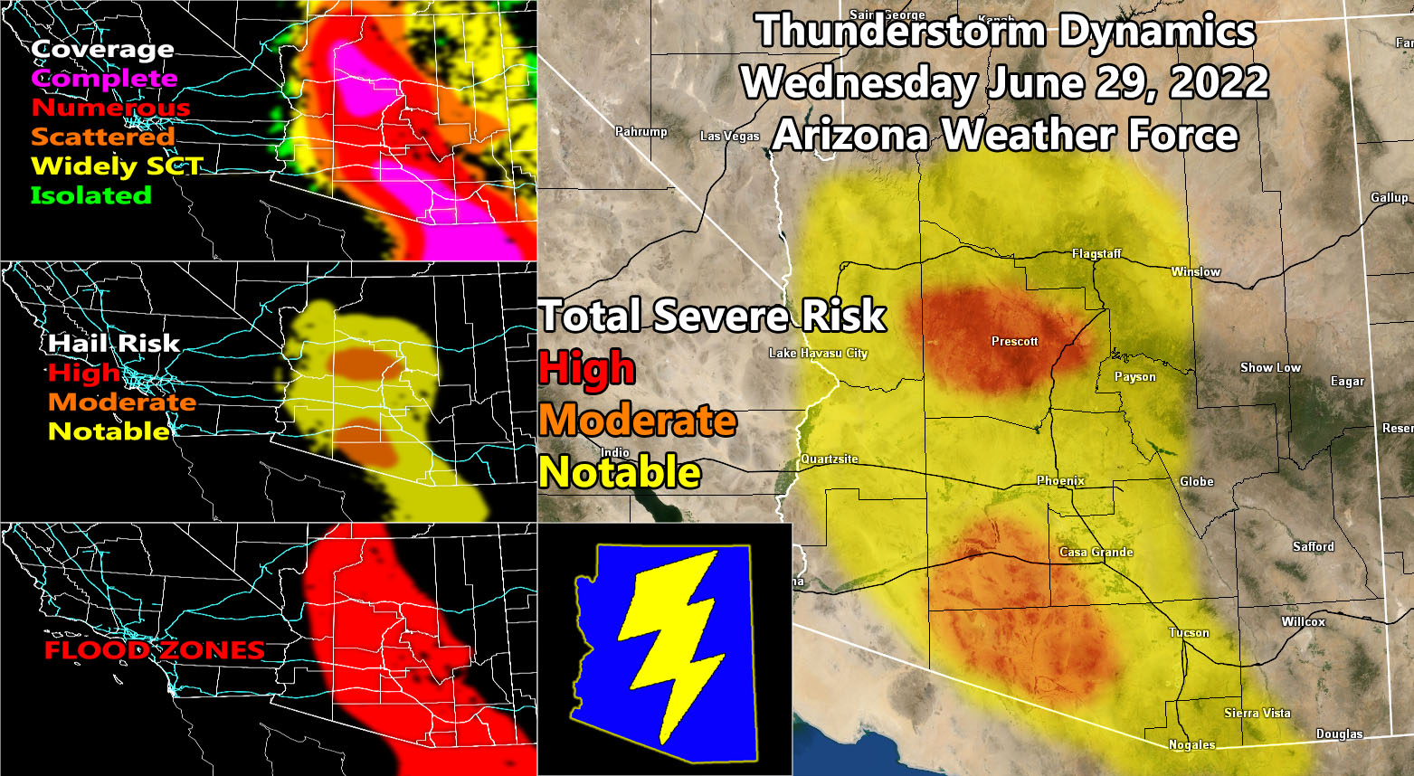
Arizona Weather Force has issued three alerts for today and tonight. Those alerts are the Severe Thunderstorm Advisory, Thunderstorm Watch (box), and Weather Advisory so read on for details and see the larger AZWF model images for rain coverage, hail risk, and flood focus zones …
Join the Facebook Page for Further Updates If You Have Not Yet!
ARIZONA WEATHER FORCE MAIN:
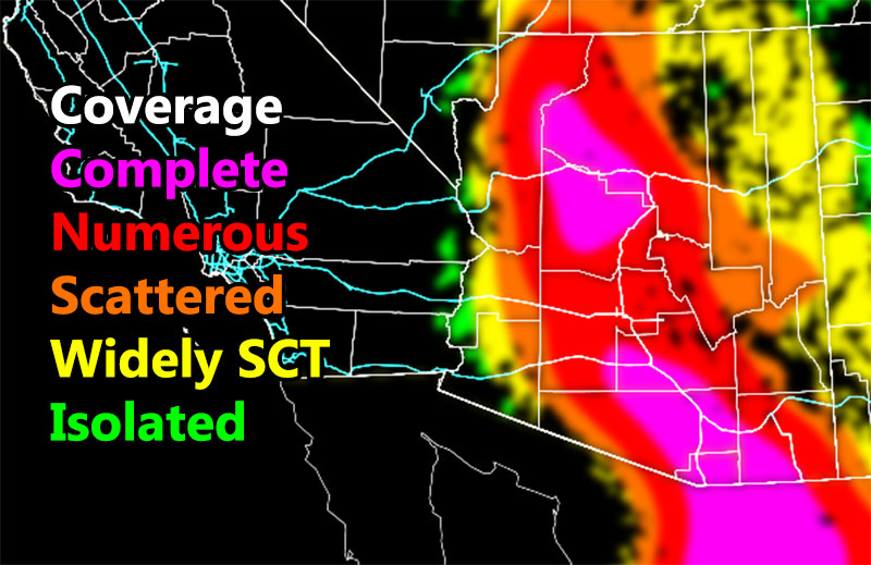
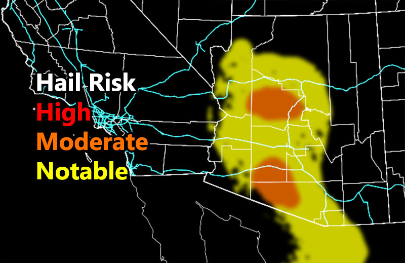
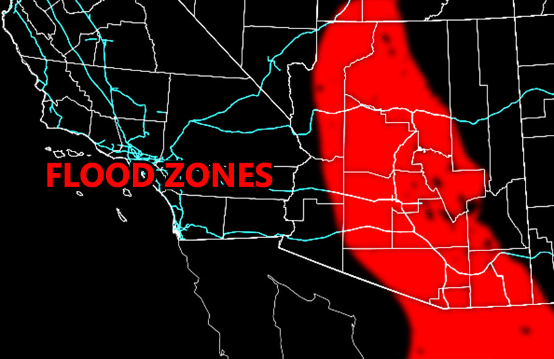
SEVERE THUNDERSTORM ADVISORY: Arizona Weather Force has issued a Severe Thunderstorm Advisory for two locations across the state. The first is the Central Yavapai County zones where the Prescott zones reside. AZWF models show a moderate risk for hail today so the strongest cells will produce larger hail. Damaging winds and flooding are also going to be likely. The second zone is the rural zones of Eastern Pima County into the Southwest Maricopa County as well, near Gila Bend and surrounding zones …There are indications that an upper-level lift source will continue the risk of thunderstorms overnight, so this may not just be a diurnal (daytime) event. With so much lift, instability, and outflow, the risk continues almost all night …
THUNDERSTORM WATCH: Arizona Weather Force has issued a Thunderstorm Watch for three major metro areas. As yesterday’s article stated (Click here), Flagstaff, Phoenix, and Tucson will be ground zero for numerous thunderstorms. These thunderstorms can contain hail, damaging winds, and even flooding as per the models below. There are indications that an upper-level lift source will continue the risk of thunderstorms overnight, so this may not just be a diurnal (daytime) event. With so much lift, instability, and outflow, the risk continues almost all night, especially across Maricopa County …
WEATHER ADVISORY: Arizona Weather Force has issued a Weather Advisory for areas surrounding the two stronger alerts, meaning hit and miss showers/thunderstorms will be in the cards along the Colorado River Valley to Cochise, Greenlee, and Graham County, including the Mogollon Rim areas. These areas are not expected to have the severe dynamics of the other watches, but they will be mentioned in the outliner all the way up to the Grand Canyon zones.
LONG RANGE: Tomorrow suggests the dynamics shift to the eastern half of the state. This means that areas that are not hit hard today like Apache and Navajo Counties will be in the firing zone for your Thursday. We lose the moisture for the Phoenix areas after that for a bit, but it will return as the trough of low pressure west of the state erodes and the monsoon ridge builds back up again after around July 7th or 8th.
STRONGEST ZONES FOR THIS EVENT: Prescott, Tonopah, Chandler
WEAKEST ZONES FOR THIS EVENT: Yuma and Bullhead City
Here are the AZWF models for this event, which will go from today into sunrise Thursday …
This was a follow-up to the following articles – You can read them and see how this forecast is evolving from Day 1.
June 28, 2022
Numerous Thunderstorms to Hit Arizona Metro Zones for Wednesday June 29th, 2022; Special Weather Statement Issued
Want these delivered to your e-mail and also the many other alerts for your area that area custom forecast for that you won’t see elsewhere? Sign-up for your free community paid for memberships for this season by going to this link – follow the terms of service directions as well – – https://arizonaweatherforce.com/?/register/BKNmp3
TWITTER: Join the AZWF Twitter For Articles By Clicking Here