As per the article way back on July 5th, the window between July 8th and the 15th would supply the metros with a lot of activity coming from the high terrain, or your north and east, and a dust storm is possible with this first round this evening so read on for details …
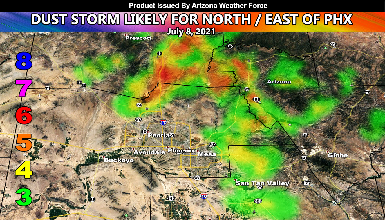
The flow is not strong, but not weak either. It is a moderate mid/upper level flow out of the northeast that will develop storms along the Mogollon Rim. These will shove through Payson and Globe. As they do so, outflow from them will split, one going for New River to Black Canyon City and the other for Gold Canyon and Queen Valley. Both of these will have the risk of thunderstorms with them as well, forming with the dust storm. Those are the main two key areas. The wind gust model provided in this article shows where the worst areas should be within Gila, Maricopa, Yavapai, and Pinal County for this evening’s outflow event.
NOTE: Travelling along I-17 north of Phoenix near and north of Black Canyon City is not recommended if you’re in a high profile vehicle. That area, with the cross outflow wind, will tip you over.
As stated in the article on July 5th (CLICK HERE) there is a break in the activity for Tucson today, but starting up again tomorrow. For the Phoenix metros, you are still scheduled for a major increase in storms toward the middle and end part of this 7-day period.
The Martin Wind Gust Intensity Model below has values as followed; The map below is clickable.
8. Extensive widespread damage.
7. Trees are broken or uprooted, building damage is considerable. – High Profile Vehicle Roll-Over CERTAIN.
6. SOME Trees are broken or uprooted, building damage is possible. – High Profile Vehicle Roll-Over Likely, Do NOT recommend Traveling in this zone
5. Slight damage occurs to buildings, shingles are blown off of roofs. HIGH WIND WARNING CRITERIA – High Profile Vehicle Roll-Over Possible if weight is not corrected.
4. Twigs and small branches are broken from trees, walking is difficult.
3. Large trees sway, becoming difficult to walk. – WIND ADVISORY CRITERIA

NEW FLAT RATE TIER PROGRAM – GET CUSTOM EMAIL WEATHER ALERTS IN YOUR AREA AND ENTER THE MEMBER SECTION ON THE SITE: Summer 2021 rates – If you get in after June 1st it is only $10, if after July 1st only $6. If after August 1st only $3 to finish off the Summer Quarterly Tier. Fall, Winter, and Spring will have their own tiers.
Both Southern California Weather Force and Arizona Weather Force have a cheap Summer 2021 discount to supercharge this service you already get on social media for free. If you do not want to miss any articles this season because social media does not show you for hours or even days (common) and want to get custom email alerts such as thunderstorm, severe thunderstorm, flood, heat, or tornado alerts along with a controllable member section model for each during the events in YOUR area, sign-up for the premium member package, which is only $10 for the Summer. Read below for details on how to join this offer.
REMEMBER… your continued want for this service is what keeps the server running and paid for. Thanks for your help!
ARIZONA WEATHER FORCE – Click here to Join Arizona Weather Force’s package