Arizona Weather Force has issued two alerts, the Thunderstorm Watch and Weather Advisory for the state of Arizona for today, Saturday June 25, 2022. I’ve decided to change the criteria of issuing a thunderstorm watch vs weather advisory during the monsoon. I will issue a weather advisory for hit and miss thunderstorm activity and keep the thunderstorm watch for more organized zones so read on for details …
Join the Facebook Page for Further Updates If You Have Not Yet!
ARIZONA WEATHER FORCE MAIN:
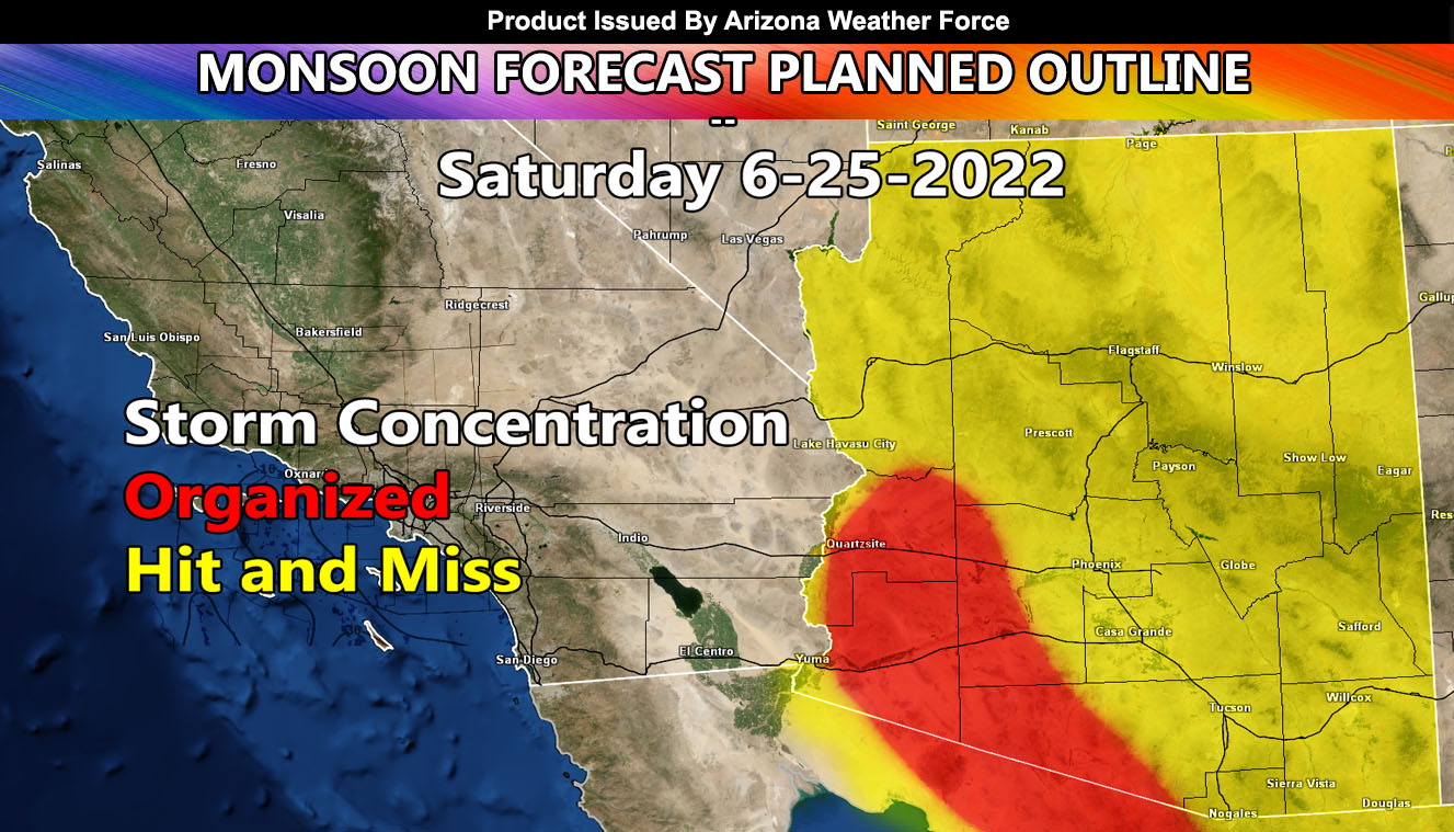
THUNDERSTORM WATCH: Arizona Weather Force has issued a Thunderstorm Watch through today for the Southwest half of Arizona. As the image above (red-shaded zone) shows, the concentration of the strongest and most numerous storm activity will be in a line from Lukeville/Ajo northwest through Yuma and La Paz Counties. Latest satellite and upper observations shows an MCV is present over Casa Grande. An MCV is a Mesoscale Convective Vorrtex, which is a small but potent area of low pressure left-over from a stronger storm complex even the night before.
This will be what will power the alerts today. Within the thunderstorm watch, some hail up to 0.75″ will be possible along with wind gusts between 45 and 55 mph. While this is just below severe limits, an Isolated severe thunderstorm cannot be ruled out due to the downbursts.
WEATHER ADVISORY: Arizona Weather Force has issued a weather advisory for hit and miss thunderstorms across the entire state, minus the Bullhead City areas. (Sorry if you are there) … As the map above shows, the entire state is under the hit and miss shade. This is simply put how the monsoon usually works without a main dynamic pushing but I do think the Phoenix forecast zones will see outflow yet again out of the north, possibly earlier than yesterday as well for hit and miss thunderstorm development.
Outflow from the Thunderstorm Watch will also push into the Yuma to Parker forecast zones for a chance of isolated thunderstorms there as well. Yuma around Wellton and Kinter especially will have the scattered storms. Unsure how far west they will go, but even if you do not get something in Yuma or Parker proper, the storms will be close enough to warrant the advisory in your area.
Cells will continue in hit and miss development across the state for most of the night, similar to last…
MOST ACTIVITY: Lukeville, Ajo, between Blythe and Wintersburg.
LEAST ACTIVITY: Casa Grande
LONG RANGE: Monsoon moisture and dynamics increase on Sunday into Monday for the metros as the ridge of high pressure over Nevada migrates eastward, bringing in that favorable and quicker flow off the Mogollon Rim.
This was a follow-up to the following articles – You can read them and see how this forecast is evolving from Day 1.
June 19, 2022
The Big Pull: Strong Surge of Monsoon Moisture To Affect All Arizona Metros This Coming Week; Daily Details
Want these delivered to your e-mail and also the many other alerts for your area that area custom forecast for that you won’t see elsewhere? Sign-up for your free community paid for memberships for this season by going to this link – follow the terms of service directions as well – – https://arizonaweatherforce.com/?/register/BKNmp3
TWITTER: Join the AZWF Twitter For Articles By Clicking Here