After a slight break with cold and sometimes freezing temperatures in the region, the last half of the Martin Storm Pattern of December 2021 is set to begin this week. For the general outlook, read on for details …
This article will contain both Southern California and Arizona Weather Force’s outlook. First and foremost, we do have yet another series of rain events to hit the forecast areas. The first, west of Los Angeles County will be expected on Wednesday, December 22nd. This slowly moves east with the warm front and eventually will cover the rest of Southern California’s forecast area by Thursday, where most of the rain from this week should fall. As Thursday hits, returning southerly flow into Arizona will start the rainfall there, light at first and then gaining steam through Friday, Christmas Eve.
Each of these rain events has a strong southerly flow with it. As stated in the long range advisory, this southerly flow means that snow-levels will be high at times, in fact most of the time this week. The atmosphere looks to be behaving like last week’s activity where end system snow-levels do eventually drop. We will see more snow this pattern in Kern County’s Mountains than mostly elsewhere due to the fact those areas are shielded from the warmer air and colder air will filter in during the end of the period.
Expecting off and on storms to continue moving through the area through the end of the month, even on Christmas weekend. Travel will be impacted at times then, especially Southern California’s forecast area south and west of the local mountains.
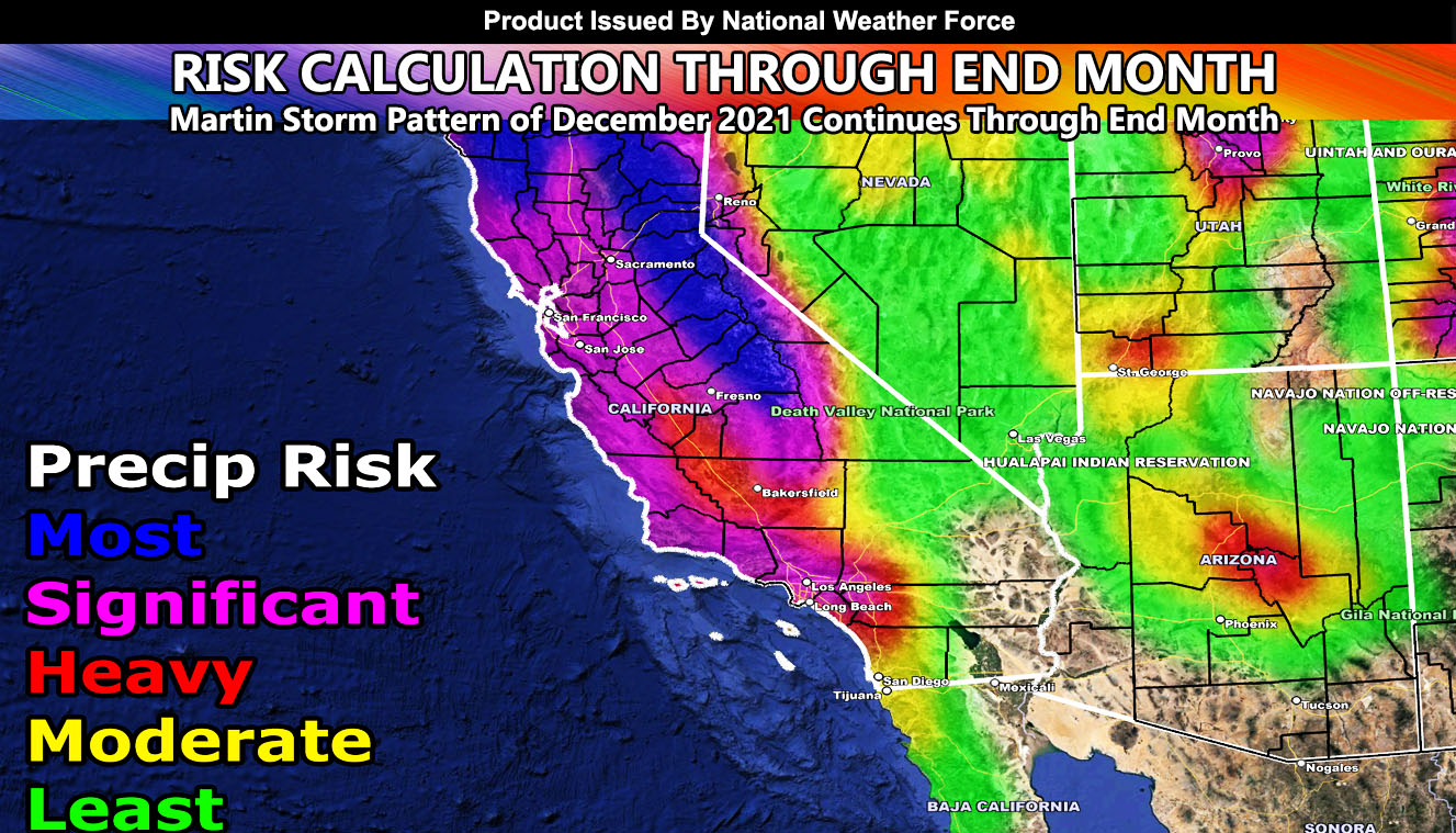
As you can see in the image of this write-up, the in-office forecast model through the end of the month clearly shows a classic sign of a major California storm event with high impacts across the Central/Northern California regions and stretching into the Southern California metro zones. You will also note that there is more rainfall for Los Angeles westward through Ventura/Santa Barbara/San Luis Obispo than say areas like San Diego and don’t even get me started with Imperial. You can also see Arizona’s highest risk area will be the Payson forecast area in terms of precipitation impacts. Like last week, this is a clear signal of a southwesterly flow, which impacts the areas closer to the south and west facing mountain slopes. It is a reason you see less in the Phoenix areas westward and move in areas like Tonto and Payson. Those are the closest areas to the sloping zones to the Mogollon Rim.
Over this week, micro-climate alerts and updates will go out on the email alert system, social media accounts, and the main website. As I stated in previous articles days and even weeks ago, continue to hold onto this month as regarded as to be active off and on through the end of it.
A Martin Storm Pattern means that the pattern was predicted before apps or government/private sources, and since my last name is Martin, like a person who discovered a comet, it is only fair this coming pattern is the Martin Storm Pattern of December 2021. There will be MANY Martin Storm Patterns due to my ability to go longer range in weather.
LONG RANGE: Long range suggests the surface ridge finally moving back to the west and bringing drier conditions the first part of January and then we snap back into the next storm pattern after then, closer to mid-month.
WANT MORE? The MAIN PAGE of this website has every alert/article issued at current. CLICK HERE TO GO
This was a follow-up to the following articles – You can read them and see how this forecast is evolving from Day 1.
November 5, 2021
HOT TOPIC: 2021-2022 Seasonal Weather Forecast Released For Southwestern United States; Detailed Maps and Discussion Within
November 29, 2021
December 2021 Weather Pattern Forecast Outlook For Arizona; December Arctic Blasts and Storms
December 15, 2021
Long Range Weather Advisory Issued: Multiple Storm Set To Hit The Southwestern United States Starting December 21st and Going Through End Month
FACEBOOK PAGES TO JOIN!
ARIZONA WEATHER FORCE MAIN: Southern California Weather Force Office Main Page For updates
If you are NOT receiving the e-mails and are a full member, your account is either expired or you need to troubleshoot. To troubleshoot, here is the link to get situated.
NOTE: You also get e-mailed alerts/articles because if you do not want to miss my social media posts, and/or I issue a product not on my social media accounts, being a supporting website member is the way to go. You get your own control panel with hundreds of zones to choose from to receive my custom alerts from. Click here if you are interested in reading more.
MAIN WEBSITE: Don’t forget. If you hear rain or anything is coming to the area. BOOKMARK THE MAIN WEBSITE BY CLICKING HERE. The stream has the latest alert links, a map of alerts and where, and articles. That is 100% free to view. There should be no reason you shouldn’t be informed.
As always, stay tuned to Arizona Weather Force for official forecasts and updates on weather across Arizona and if it says ‘like page’ below, hit the button and get future updates. If it says liked, don’t hit it because that’s unfollowing and you won’t get updates at AZWF page on your feed